Computational Methods
Prof. Dr.-Ing. Youness Dehbi
Lehre im Sommersester
- Sensornetzwerke und IoT (B.Sc.)
- Informatik 2 (B.Sc. TGA)
- Raumbezogene Datenanalyse (B.Sc.)
- Big Data Analytics (M.Sc.)
- Digitale Theorie / BIM (M.Sc.)
Lehre im Wintersemester
- Geodatenverwaltung und -analyse (B.Sc.)
- Grundlagen der Geoinformatik (B.Sc.)
- Geodateninfrastrukturen (B.Sc.)
- Mathematik 3 (B.Sc.)
- Informatik 3 (B.Sc.)
- Engineering Mathematics (M.Sc.)
- Ingenieurmathematik (M.Sc.)
Vita
- seit 03/2023:
Professor für Computational Methods an der HafenCity Universität Hamburg - 09/2016 bis 02/2023:
Akademischer Rat am Institut für Geodäsie und Geoinformation an der Universität Bonn - 08/2008 bis 09/2016:
Wissenschaftlicher Mitarbeiter am Institut für Geodäsie und Geoinformation an der Universität Bonn - 10/2003 bis 05/2008:
Studium der Informatik und Kommunikationsforschung an der Universität Bonn
Auszeichnungen
- 2024: "Best Paper Award in the Category Smart People, 8th International Conference on Smart Data and Smart Cities (SDSC2024), Athens"
- 2023: "Best Paper Award in the Digital Construction: BIM Application Workshop, Geospatial Week, Cairo, Egypt"
- 2021: "Best Reviewer Award of the ISPRS Congress, Nice, France"
- 2019: "Best Paper Award at the 14th 3D GeoInfo Conference, Singapore"
- 2019: "Best Paper Award at the 4th International Conference on Smart Data and Smart Cities, Kuala Lumpur, Malaysia"
- 2018: "Best Paper Award at the 3rd International Conference on Smart Data and Smart Cities, Delft, Netherlands"
Gremienarbeit
Advisor of the International Society of Photogrammetry and Remote Sensing working group IV/9 (ISPRS WG IV/9)
"Spatially Enabled Urban and Regional Digital Twins" www2.isprs.org/commissions/comm4/wg9/
2026
W. Li, J. Zhu, Q. Zhu, J. Zhang, J. Wu,Y. Dehbi. Spatial Modelling for Bridge Construction Environment Towards Geospatial Digital Twin, 2026, International Journal of Applied Earth Observation and Geoinformation, (Accepted for publication).
L. Arzoumanidis, A. M. As Samee, E. Kanna, S. H. Nguyen, Y. Dehbi. Domain-Adaptive Object Detection for Enriching Semantic 3D City Models with Building Storeys from Street-View Images, ISPRS Ann. Photogramm. Remote Sens. Spatial Inf. Sci., 2026, Accepted for publication.
L. Arzoumanidis, W. Li, Y. Dehbi. Domain-Adaptive Object Detection of Electrical Facilities for Enhanced Semantic Indoor Models, ISPRS Ann. Photogramm. Remote Sens. Spatial Inf. Sci., 2026, Accepted for publication.
E. Kanna, J. Matijevic, L. Arzoumanidis, S. H. Nguyen, Y. Dehbi. Semantic Enrichment of 3D City Models via Roof-material Classification for Urban Greening and Heat Island Mitigation. 2026. preprint http://dx.doi.org/10.2139/ssrn.6127041
2025
L. Arzoumanidis, J. Knechtel, JH. Haunert, Y. Dehbi. Automatic Uncertainty-Aware Synthetic Data Bootstrapping for Historical Map Segmentation. arXiv preprint arXiv:2511.13742, 2025, https://doi.org/10.48550/arXiv.2511.15875
J. Hecht, W. Li, Z. Li, Y. Dehbi. Review of Passenger Flow Modeling Approaches Based on a Bibliometric Analysis. arXiv preprint arXiv:2511.13742, 2025, doi.org/10.48550/arXiv.2511.13742.
Li, W., Matijevic, J., Beil, C., Arzoumanidis, L., Kolbe, TH, & Dehbi, Y. (2025). Bidirectional enrichment of OpenStreetMap and CityGML 3.0 to facilitate cycling safety assessment. International Journal of Geographical Information Science, 1–24. https://doi.org/10.1080/13658816.2025.2595662
W. Li, J. Zhu, S. Pirasteh, Q. Zhu, Y. Guo, L. Luo, Y. Dehbi "A 3D virtual geographic environment for flood representation towards risk communication" arXiv preprint arXiv:2512.03839, 2025, http://doi.org/10.48550/arXiv.2512.03839
Y. Dehbi, E. Kanna, S. Koppers, L. Plümer. Using deformations of measuring noise distributions for the discrimination of 3d building model parts. Accepted for the Second Edition of the Mediterranean Smart Cities Conference (MSCC'2025)
Jaisawal, PK, Dehbi, Y. and Sternberg, H., 2025. Particle Filter-Based Indoor Localization with Learning Based PDR and Monocular Depth-Aided BIM Matching. IPIN-WCAL 2025 : Proceedings of the Workshop for Computing & Advanced Localization at the Fifteenth International Conference on Indoor Positioning and Indoor Navigation, September 15-18, 2025, Tampere, Finland. Conference Paper (Best Poster Award).
L. Arzoumanidis, SH Nguyen, L. Johannsen, F. Rothaut, W. Li, and Y. Dehbi: Object Detection for the Enrichment of Semantic 3D City Models with Roofing Materials, ISPRS Ann. Photogram. Remote Sens. Spatial Inf. Sci . ,
Knechtel J, Dehbi Y, Klingbeil L, Haunert JH. Simultaneous planning of standpoints and routing for laser scanning of buildings with network redundancy. ISPRS Journal of Photogrammetry and Remote Sensing. 2025 Jun 1;224:59-74.
Bolte AM, Kistemann T, Dehbi Y, Kötter T. (Un)just Distribution of Visible Green Spaces? A Socio-Economic Window View Analysis on Residential Buildings: The City of Cologne as Case Study. Journal of Geovisualization and Spatial Analysis. 2025 Jun;9(1):17.
D. Baltzer, S. Douglas, J.-H. Haunert, Y. Dehbi, I. Tiemann, Smart Glasses in the Chicken Barn: Enhancing Animal Welfare Through Mixed Reality, Smart Agricultural Technology, 2025
L. Arzoumanidis, J. Knechtel, J.-H. Haunert, and Y. Dehbi, 2025. Semantic Segmentation of Historical Maps using Self-Constructing Graph Convolutional Networks. Cartography and Geographic Information Science. doi.org/10.1080/15230406.2025.2468304 .
L. Arzoumanidis*, J. Knechtel*, G. Sen*, W. Li, & Y. Dehbi (2025). Rooftop Drainage Outlets and Ventilations Dataset. Automatic Detection of Tiny Drainage Outlets and Ventilations on Flat Rooftops from Aerial Imagery (GSW'2025), Dubai. doi.org/10.5281/zenodo.14040571 .
L. Arzoumanidis, W. Li, J. Knechtel, Y. Kosmayadi, Y. Dehbi, Automatic Detection of Tiny Drainage Outlets and Ventilations on Flat Rooftops from Aerial Imagery, ISPRS Ann. Photogram. Remote Sens . Spatial Inf. Sci . ,
A.-M. Bolte, T. Kistemann, T. Kötter, Y. Dehbi, Validating a window view simulation engine based on open data and open source using semantic segmentation, ISPRS GeoSpatial Week Dubai, Int. Arch. Photogram. Remote Sens. Spatial Inf. Sci., 2025
2024
W. Li, JH. Haunert, A. Forsch, J. Zhu, Q. Zhu, Y. Dehbi, Informed sampling and recommendation of cycling routes: leveraging crowd-sourced trajectories with weighted-latent Dirichlet allocation, International Journal of Geographical Information Science, 2024, 1-22, https://doi.org/10.1080/13658816.2024.2391428
J. Knechtel, P. Rottmann, JH. Haunert, Y. Dehbi, Semantic floor plan segmentation using self-constructing graph networks, Automation in Construction, Volume 166, 2024, 105649, ISSN 0926-5805, doi.org/10.1016/j.autcon.2024.105649.
Arzoumanidis L, Fethers JO, Mudiyanselage SH, Dehbi Y (2024). Deep Generation of Synthetic Training Data for the Automated Extraction of Semantic Knowledge from Historical Maps. Abstracts of the International Cartographic Association. EuroCarto (2024), Vienna, Austria. doi.org/10.5194/ica-abs-7-7-2024 .
W. Li, L. Arzoumanidis, J. Matijevic, D. Mohammed, P. Rottmann, J.-H. Haunert, & Y. Dehbi (2024). Safety assessment of cycling routes in urban environments. Int. Arch. Photogram. Remote Sens. Spatial Inf. Sci., XLVIII-4/W10-2024, 125–130, Smart Data and Smart Cities Conference, Athens, 2024. doi.org/10.5194/isprs-archives-XLVIII-4-W10-2024-125-2024 . ( Best Paper Award in the Smart People Category )
Arzoumanidis, L., Hecht, J., and Dehbi, Y.: Towards a Deep Automatic Generation of Figure-ground Maps, ISPRS Ann. Photogram. Remote Sens. Spatial Inf. Sci.,
Weilian Li, Jun Zhu, Saied Pirasteh, Qing Zhu, Yukun Guo, Lan Luo, Youness Dehbi, A 3D virtual geographic environment for flood representation towards risk communication, 2024, International Journal of Applied Earth Observation. https://doi.org/10.1016/j.jag.2024.103757
Weilian Li, Jun Zhu, Qing Zhu, Zhang Jinbin, Xiao Han, Youness Dehbi. Visual attention-guided augmented representation of geographic scenes: A case of bridge stress visualization, International Journal of Geographical Information Science, 1-23, 2024. https://doi.org/10.1080/13658816.2023.2301313
A. Bolte, B. Niedermann, T. Kistemann, J.-H. Haunert, Y. Dehbi and T. Kötter. The green window view index: automated multi-source visibility analysis for a multi-scale assessment of green window views. Landscape Ecology 39, 71 (2024). doi.org/10.1007/s10980-024-01871-7
2023
L. Arzoumanidis, A. Forsch, J.-H. Haunert and Y. Dehbi. Catchment cell visualization for multi-modal public transportation networks. 1st ACM SIGSPATIAL Workshop on Sustainable Mobility, Hamburg, 2023. https://dl.acm.org/doi/10.1145/3615899.3627931
J. M.-Lietzkow, C. Nataliya and Y. Dehbi. FPOPlus: Cutting-Edge Technology for Sustainable Future Mobility. 1st ACM SIGSPATIAL Workshop on Sustainable Mobility, 2024.
W. Li, J.-H. Haunert, J. Knechtel, J. Zhu, Q. Zhu, and Y. Dehbi. Social Media Insights on Public Perception and Sentiment During and After Disasters: The European Floods in 2021 as a Case Study. Transactions in GIS, 27(6):1766-1793, 2023. https://doi.org/10.1111/tgis.13097
J. Knechtel, W. Li, Y. Orgeig, J.-H. Haunert and Y. Dehbi. Immersive virtual reality to verify the as-built state of electric line networks in buildings. n: Kolbe, T.H., Donaubauer, A., Beil, C. (eds) Recent Advances in 3D Geoinformation Science. 3DGeoInfo 2023. Lecture Notes in Geoinformation and Cartography. Springer, Cham. doi.org/10.1007/978-3-031-43699-4_8
J. Knechtel, J. Behmann, J.-H. Haunert and Y. Dehbi. Suitability Assessment of Different Sensors to Detect Hidden Installations for As-built BIM. SUITABILITY ASSESSMENT OF DIFFERENT SENSORS TO DETECT HIDDEN INSTALLATIONS FOR AS-BUILT BIM, ISPRS Ann. Photogramm. Remote Sens. Spatial Inf. Sci., X-1/W1-2023, 263–270, doi.org/10.5194/isprs-annals-X-1-W1-2023-263-2023, 2023. (Best Paper Award in the Digital Construction: BIM Application Workshop)
W. Li, N. Treff, F. Amann, J. Lehmen, Y. Dehbi and J.-H. Haunert. AN INTERACTIVE EVACUATION TOOL TO IMPROVE THE PUBLIC FLOOD PERCEPTION, Int. Arch. Photogramm. Remote Sens. Spatial Inf. Sci., XLVIII-1/W2-2023, 437–442, doi.org/10.5194/isprs-archives-XLVIII-1-W2-2023-437-2023, 2023.
L. Arzoumanidis, J. Knechtel, J.-H. Haunert and Y. Dehbi. Self-Constructing Graph Convolutional Networks for Semantic Segmentation of Historical Maps. Abstracts of the International Cartographic Association, 6, 11, 2023. 31st International Cartographic Conference (ICC 2023), 13–18 August 2023, Cape Town, South Africa. doi.org/10.5194/ica-abs-6-11-2023.
W. Li, Y. Guo, J.-H. Haunert, Y. Dehbi. Integrating cellular automata model into 3D representation for enhancing flood risk communication. Abstracts of the International Cartographic Association, 6, 139, 2023. 31st International Cartographic Conference (ICC 2023), 13–18 August 2023, Cape Town, South Africa. doi.org/10.5194/ica-abs-6-139-2023.
2022
Y. Dehbi, J. Knechtel, B. Niedermann, and J.-H. Haunert. Incremental constraint-based reasoning for estimating as-built electric line routing in buildings. Automation in Construction, 143:104571, 2022. https://doi.org/10.1016/j.autcon.2022.104571
L. Weilian, Z. Jun, J.-H. Haunert, F. Lin, Z. Qing, and Y. Dehbi. Three-dimensional virtual representation for the whole process of dam-break floods from a geospatial storytelling perspective. International Journal of Digital Earth, 15:1637-1656, 2022. https://doi.org/10.1080/17538947.2022.2118877
P. Rottmann, J.-H. Haunert, and Y. Dehbi. Automatic building footprint extraction from 3d laserscans. ISPRS Annals of the Photogrammetry, Remote Sensing and Spatial Information Sciences, X-4/W2-2022:233-240, 2022. https://isprs-annals.copernicus.org/articles/X-4-W2-2022/233/2022/
Victor Korir, Axel Forsch, Youness Dehbi, and Jan-Henrik Haunert. Visualizing the modal split in public transportation networks. Abstracts of the ICA, 5:89, sep 2022.
J. Knechtel, L. Klingbeil, J.-H. Haunert, and Y. Dehbi. Optimal position and path planning for stop-and-go laserscanning for the acquisition of 3d building models. ISPRS Annals of the Photogrammetry, Remote Sensing and Spatial Information Sciences, V-4-2022:129-136, 2022. https://isprs-annals.copernicus.org/articles/V-4-2022/129/2022/
W. Li, J. Zhu, S. Pirasteh, Q. Zhu, L. Fu, J. Wu, Y. Hu, and Y. Dehbi. Investigations of disaster information representation from a geospatial perspective: progress, challenges and recommendations. Transactions in GIS, 26(3):1376-1398, 2022. https://doi.org/10.1111/tgis.12922
Barramou, Fatimazahra, Khalifa Mansouri, and Youness Dehbi, eds. Geospatial Intelligence: Applications and Future Trends. Springer International Publishing, 2022.
2021
Youness Dehbi, Johannes Leonhardt, Johannes Oehrlein, and Jan-Henrik Haunert. Optimal scan planning with enforced network connectivity for the acquisition of three-dimensional indoor models. ISPRS Journal of Photogrammetry and Remote Sensing, 180:103-116, 2021. https://doi.org/10.1016/j.isprsjprs.2021.07.013
L. Lucks, L. Klingbeil, L. Plümer, and Y. Dehbi. Improving trajectory estimation using 3d city models and kinematic point clouds. Transactions in GIS, 25(1):238-260, 2021. https://doi.org/10.1111/tgis.12719
Y. Dehbi, A. Henn, G. Gröger, V. Stroh, and L. Plümer. Robust and fast reconstruction of complex roofs with active sampling from 3d point clouds. Transactions in GIS, 25(1):112-133, 2021. https://doi.org/10.1111/tgis.12659
Y. Dehbi, S. Koppers, and L. Plümer. Looking for a needle in a haystack: probability density based classification and reconstruction of dormers from 3d point clouds. Transactions in GIS, 25(1):44-70, 2021. https://doi.org/10.1111/tgis.12658
Axel Forsch, Youness Dehbi, Benjamin Niedermann, Johannes Oehrlein, Peter Rottmann, and Jan-Henrik Haunert. Multimodal travel-time maps with formally correct and schematic isochrones. Transactions in GIS, 25(6):3233-3256, 2021. https://doi.org/10.1111/tgis.12821
2020
Y. Dehbi, L. Klingbeil, and L. Plümer. Uav mission planning for automatic exploration and semantic mapping. ISPRS - International Archives of the Photogrammetry, Remote Sensing and Spatial Information Sciences, XLIII-B1-2020:521-526, 2020
2019
Y. Dehbi, A. Henn, G. Gröger, V. Stroh, and L. Plümer. Active sampling and model based prediction for fast and robust detection and reconstruction of complex roofs in 3d point clouds. In volume IV-4/W8 of ISPRS Annals of the Photogrammetry, Remote Sensing and Spatial Information Sciences. Proc. 14th 3D Geoinfo Conference, pages 43-50. 2019. (Best Paper Award)
F. Biljecki, and Y. Dehbi. Raise the roof: towards generating lod2 models without aerial surveys using machine learning. In volume IV-4/W8 of ISPRS Annals of the Photogrammetry, Remote Sensing and Spatial Information Sciences. Proc. 14th 3D Geoinfo Conference, pages 27-34. 2019.
Y. Dehbi, S. Koppers, and L. Plümer. Probability density based classification and reconstruction of roof structures from 3d point clouds. In volume XLII-4/W16 of ISPRS - International Archives of the Photogrammetry, Remote Sensing and Spatial Information Sciences. Proc. 6th International Conference on Geomatics and Geospatial Technology, pages 177-184. 2019.
Y. Dehbi, L. Lucks, J. Behmann, L. klingbeil, and L. Plümer. Improving gps trajectories using 3d city models and kinematic point clouds. In volume IV-4/W9 of ISPRS Annals of the Photogrammetry, Remote Sensing and Spatial Information Sciences. Proc. 4th International Conference on Smart Data and Smart Cities, pages 35-42. 2019. (Best Paper Award)
2018
J. Oehrlein, A. Förster, D. Schunck, Y. Dehbi, R. Roscher, and J.-H. Haunert. Inferring routing preferences of bicyclists from sparse sets of trajectories. In volume IV-4/W7 of ISPRS Annals of the Photogrammetry, Remote Sensing and Spatial Information Sciences. Proc. 3rd International Conference on Smart Data and Smart Cities, pages 107-114. 2018. ( Best Paper Award )
Y. Dehbi, N. Gojayeva, AR Pickert, J.-H. Haunert, and L. Plümer. Room shapes and functional uses predicted from sparse data. In volume IV-4:33-40 of ISPRS Annals of the Photogrammetry, Remote Sensing and Spatial Information Sciences. Proc. ISPRS Technical Commission IV Symposium. 2018.
2017
Y. Dehbi, J.-H. Haunert, and L. Plümer. Stochastic and geometric reasoning for indoor building models with electrical installations - bridging the gap between gis and bim. In volume IV-4/W5 of ISPRS Annals of Photogrammetry, Remote Sensing and Spatial Information Sciences. Proc. 12th 3D Geoinfo Conference, pages 33-39. 2017.
Y. Dehbi, S. Loch-Dehbi, and L. Plümer. Parameter estimation and model selection for indoor models based on sparse observations. In volume IV-2/W4 of ISPRS Annals of Photogrammetry, Remote Sensing and Spatial Information Sciences. Proc. ISPRS Geospatial Week 2017, pages 303-310. 2017.
Y. Dehbi, F. Hadiji, Gerhard Gröger, Kristian Kersting, and L. Plümer. Statistical relational learning of grammar rules for 3d building reconstruction. Transactions in GIS, 21(1):134-150, 2017. https://doi.org/10.1111/tgis.12200
S. Loch-Dehbi, Y. Dehbi, and L. Plümer. Estimation of 3d indoor models with constraint propagation and stochastic reasoning in the absence of indoor measurements. ISPRS International Journal of Geo-Information, 6(3), 2017.
2016
Y. Dehbi, Gerhard Gröger, and L. Plümer. Identification and modeling of translational and axial symmetries and their hierarchical structures in building footprints by formal grammars. Transactions in GIS, 20(5):645-663, 2016. https://doi.org/10.1111/tgis.12177
Y. Dehbi. Statistical relational learning of semantic models and grammar rules for 3D building reconstruction from 3D point clouds. University and State Library Bonn. University of Bonn, Germany, 2016. Dissertation.
Y Dehbi, C Staat, L Mandtler, and L Plümer. Incremental refinement of facade models with attribute grammar from 3d point clouds. In volume III-3 of ISPRS Annals of Photogrammetry, Remote Sensing and Spatial Information Sciences. Proc. XXIII ISPRS Congress, pages 311-316. 2016.
S. Loch-Dehbi, Y. Dehbi, G. Gröger, and L. Plümer. Prediction of building floorplans using logical and stochastic reasoning based on sparse observations. In volume IV-2/W1 of ISPRS Annals of Photogrammetry, Remote Sensing and Spatial Information Sciences. Proc. 11th 3D Geoinfo Conference, pages 265-270. 2016.
2013
S. Loch-Dehbi, Y. Dehbi, and L. Plümer. Stochastic reasoning for uav supported reconstruction of 3d building models. In volume XL-1/W2 of ISPRS Annals of Photogrammetry, Remote Sensing and Spatial Information Sciences. Proc. UAV-g Conference 2013, pages 257-261. 2013.
2011
Y. Dehbi, and L. Plümer. Learning grammar rules of building parts from precise models and noisy observations. ISPRS Journal of Photogrammetry and Remote Sensing, 66(2):166-6176, 2011. Quality, Scale and Analysis Aspects of Urban City Models. https://doi.org/10.1016/j.isprsjprs.2010.10.001
2010
Y. Dehbi, Jörg Schmittwilken, and L. Plümer. Learning semantic models and grammar rules of building parts. In Proc. 24th Workshop on Constraint Logic Programming (WLP 2010), pages 45-56. German University in Cairo, 2010.
2009
Y. Dehbi, Jörg Schmittwilken, and L. Plümer. Learning semantic models and grammar rules of building parts. In volume XXXVIII-2/W11 of ISPRS Archives of Photogrammetry, Remote Sensing and Spatial Information Sciences. Proc. of the ISPRS WG II/2+3+4 and Cost Workshop. Lund, Sweden 2009. 2009.
Lukas Arzoumanidis, M.Sc.

lukas.arzoumanidis(at)hcu-hamburg.de
+49 04300880 - 5360
Room: 4.178 (4.183)
Henning-Voscherau-Platz 1
20457 Hamburg
- seit 05/2023:
Wissenschaftlicher Mitarbeiter und Doktorand an der HafenCity Universität Hamburg, Computational Methods - 07/2021 bis 03/2023:
Studentische Hilfskraft bei der Gruppe Geoinformation am Institut für Geodäsie und Geoinformation an der Universität Bonn - 10/2020 bis 12/2022:
Masterstudium Geodetic Engineering an der Universität Bonn - 10/2018 bis 06/2021:
Geoinformatiker bei Wasserverband Rhein-Sieg-Kreis - 04/2019 bis 08/2019:
Tutor der Geoinformation und Fernerkundung am geographischen Institut der Universität Bonn - 10/2017 bis 09/2020:
Bachelorstudium der Geographie an der Universität Bonn
2026
Lukas Arzoumanidis, Falko Behre, Malte Marsmann, Weilian Li, Youness Dehbi. (2026). Object Detection Benchmark Dataset for Indoor Power Sockets and Light Switches. Zenodo. doi.org/10.5281/zenodo.18835199
Lukas Arzoumanidis, Al Maimun As Samee, Elmehdi Kanna, Son H. Nguyen, Youness Dehbi: Domain-Adaptive Object Detection for Enriching Semantic 3D City Models with Building Storeys from Street-View Images, ISPRS Ann. Photogramm. Remote Sens. Spatial Inf. Sci., 2026, Accepted for publication.
Lukas Arzoumanidis, Weilian Li, Youness Dehbi: Domain-Adaptive Object Detection of Electrical Facilities for Enhanced Semantic Indoor Models, ISPRS Ann. Photogramm. Remote Sens. Spatial Inf. Sci., 2026, Accepted for publication.
2025
Weilian Li, Jannik Matijevic, Christof Beil, Lukas Arzoumanidis, Thomas H. Kolbe, Youness Dehbi. 2025. Bidirectional enrichment of OpenStreetMap and CityGML 3.0 to facilitate cycling safety assessment. International Journal of Geographical Information Science, 1–24. https://doi.org/10.1080/13658816.2025.2595662
Lukas Arzoumanidis, Jannik Matijevic, Lena Hildebrandt, Julius Knechtel, Jan-Henrik Haunert, Staatsbibliothek zu Berlin SPK, Youness Dehbi (2025). Semantic Segmentation Benchmark Dataset for Homogeneous Historical Map Corpora. https://doi.org/10.5281/zenodo.17579452.
Lukas Arzoumanidis. Objekterkennung zur Anreicherung semantischer 3D-Stadtmodelle mit Dachmaterialien. 3D Stadtmodelle. DGPF & DGfK, 05.11.2025.
Lukas Arzoumanidis, Son H. Nguyen, Lara Johannsen, Filip Rothaut, Weilian Li, Youness Dehbi: Object Detection for the Enrichment of Semantic 3D City Models with Roofing Materials, ISPRS Ann. Photogramm. Remote Sens. Spatial Inf. Sci., X-4/W6-2025, 9–16, doi.org/10.5194/isprs-annals-X-4-W6-2025-9-2025, 2025.
Lukas Arzoumanidis, Julius Knechtel, Jan-Henrik Haunert, and Youness Dehbi. 2025. Semantic Segmentation of Historical Maps using Self-Constructing Graph Convolutional Networks. Cartography and Geographic Information Science. doi.org/10.1080/15230406.2025.2468304.
Lukas Arzoumanidis, Weilian Li, Julius Knechtel, Yudha Kosmayadi, Youness Dehbi, Automatic Detection of Tiny Drainage Outlets and Ventilations on Flat Rooftops from Aerial Imagery, ISPRS Ann. Photogramm. Remote Sens. Spatial Inf. Sci., X-G-2025, 125–132, doi.org/10.5194/isprs-annals-X-G-2025-125-2025, 2025.
Lukas Arzoumanidis, Julius Knechtel, Gizem Sen, Weilian Li, Youness Dehbi (2025). Rooftop Drainage Outlets and Ventilations Dataset. Automatic Detection of Tiny Drainage Outlets and Ventilations on Flat Rooftops from Aerial Imagery (GSW'2025), Dubai. doi.org/10.5281/zenodo.14040571.
Lukas Arzoumanidis. Deep Learning trifft historische Karten: Trainingsinstanzen und Extraktion semantischen Wissens auf Knopfdruck. Deutsche Gesellschaft für Kartographie e.V. (DGfK), CartoCafé 1/25. 09.01.2025. Video. Schriftliche Kurzzusammenfassung.
2024
Lukas Arzoumanidis, James Ormond Fethers, Sethmiya Herath Mudiyanselage, Youness Dehbi (2024). Deep Generation of Synthetic Training Data for the Automated Extraction of Semantic Knowledge from Historical Maps. Abstracts of the International Cartographic Association. EuroCarto (2024), Vienna, Austria. doi.org/10.5194/ica-abs-7-7-2024.
Weilian Li, Lukas Arzoumanidis, Jannik Matijevic, Daham Mohammed, Peter Rottmann, Jan-Henrik Haunert, & Youness Dehbi (2024). Safety assessment of cycling routes in urban environments. Int. Arch. Photogramm. Remote Sens. Spatial Inf. Sci., XLVIII-4/W10-2024, 125–130, Smart Data and Smart Cities Conference, Athens, 2024. doi.org/10.5194/isprs-archives-XLVIII-4-W10-2024-125-2024.
Lukas Arzoumanidis., Jonathan Hecht, and Youness Dehbi: Towards a Deep Automatic Generation of Figure-ground Maps, ISPRS Ann. Photogramm. Remote Sens. Spatial Inf. Sci., X-4/W5-2024, 33–39, doi.org/10.5194/isprs-annals-X-4-W5-2024-33-2024, 2024.
Sven Gedicke, Lukas Arzoumanidis, and Jan-Henrik Haunert. Ein Algorithmus zur automatischen Platzierung taktischer Zeichen in der digitalen Lageskizze (2024). 112Rescue 2023. Sammelband des Tages der Sicherheitsforschung. Dortmund. 14.-17.06.2023.
2023
Lukas Arzoumanidis, Axel Forsch, Jan-Henrik Haunert and Youness Dehbi. Catchment cell visualization for multi-modal public transportation networks. 1st ACM SIGSPATIAL Workshop on Sustainable Mobility, Hamburg, 2023. doi.org/10.1145/3615899.3627931.
Sven Gedicke, Lukas Arzoumanidis, and Jan-Henrik Haunert. Ein Algorithmus zur automatischen Platzierung taktischer Zeichen in der digitalen Lageskizze. Zeitschrift für Forschung und Technik im Brandschutz vfdb, 72(2):59-65, 2023.
Lukas Arzoumanidis, Julius Knechtel, Jan-Henrik Haunert and Youness Dehbi. Self-Constructing Graph Convolutional Networks for Semantic Segmentation of Historical Maps. Abstracts of the International Cartographic Association, 6, 11. 31st International Cartographic Conference (ICC 2023), Cape Town, South Africa. doi.org/10.5194/ica-abs-6-11-2023.
Sven Gedicke, Lukas Arzoumanidis, and Jan-Henrik Haunert. Automating the External Placement of Symbols for Point Features in Situation Maps for Emergency Response. Cartography and Geographic Information Science, 50(4):385-402, 2023, doi.org/10.1080/15230406.2023.2213446.
Dr. rer. nat. Son H. Nguyen
son.nguyen(at)hcu-hamburg.de
+49 040 300 880 - 2797
Raum: 4.182
Henning-Voscherau-Platz 1
20457 Hamburg
Vita
- seit 01/2025: Postdoktorand (Dr. rer. nat.), im Bereich Knowledge Graphs und Effiziente Algorithmen, an der HafenCity Universität Hamburg, Computational Methods Lab (Prof. Youness Dehbi)
- 06/2017 - 12/2024: Wissenschaftlicher Mitarbeiter und Doktorand, im Bereich Graph-basierte Änderungsdetektion und Interpretation in massiven semantischen 3D-Stadtmodellen, an der Technischen Universität München, TUM School of Engineering and Design, Fakultät für Luftfahrt, Raumfahrt und Geodäsie, Lehrstuhl für Geoinformatik (Prof. Thomas H. Kolbe)
- 10/2014 - 05/2017: M.Sc. in Informatik (mit Vertiefung in Robotik und Geoinformatik) an der Technischen Universität München, Fakultät für Informatik
- 10/2011 - 09/2014: B.Sc. in Informatik (mit Vertiefung in Mathematik und im autonomen Fahren) an der Technischen Universität München, Fakultät für Informatik
- 09/2010 - 09/2011: Studienkolleg (T-Kurs) München
- 09/2009 - 08/2010: B.Sc. in Informatik an der Ho Chi Minh City University of Technology
- 09/2006 - 08/2009: Le Hong Phong Highschool für die Begabten (Leistungskurs in Physik), Ho Chi Minh Stadt, Vietnam
Auszeichnungen
- 2025: Beste Dissertation und Beste PhD-Präsentation, Förderpreise Runder Tisch GIS e.V. 2025, Technische Universität München
- 2024: Auszeichnung summa cum laude, Dissertation "Automatic Detection and Interpretation of Changes in Massive Semantic 3D City Models", Technische Universität München
- 2024: Anerkennung für besondere Leistungen in der Forschung und Lehre an der Technischen Universität München
- 2023: Anerkennung für besondere Leistungen in der Forschung und Lehre an der Technischen Universität München
- 2022: Best Young Researcher Paper Award, Konferenz 3D GeoInfo 2022 in University of New South Wales in Sydney, Australien, Artikel "Path-tracing Semantic Networks to Interpret Changes in Semantic 3D City Models", Autoren: Son H. Nguyen, Thomas H. Kolbe
- 2021: Outstanding Paper Award, Online-Konferenz 3D GeoInfo 2021 in New York University in New York City, USA, Artikel "Modelling Changes, Stakeholders and their Relations in Semantic 3D City Models", Autoren: Son H. Nguyen, Thomas H. Kolbe, Track: 3D City Modelling
- 2020: Goldene Lehre, Beste Übung in "Geoinformatik Projektarbeit" (Wintersemester 2019/2020), Technische Universität München, Fachschaft der Fakultät für Luftfahrt, Raumfahrt und Geodäsie
- 2020: Goldene Lehre, Beste Übung in "Einführung in die Informatik 2 (Übung)" (Sommersemester 2020), Technische Universität München, Fachschaft der Fakultät für Luftfahrt, Raumfahrt und Geodäsie
2026
Arzoumanidis, L., As Samee A.M., Kanna, E., Nguyen, Son H. ,Dehbi, Y.: Domain-Adaptive Object Detection for Enriching Semantic 3D City Models with Building Storeys from Street-View Images, ISPRS Ann. Photogramm. Remote Sens. Spatial Inf. Sci., 2026, Accepted for publication.
2025
Arzoumanidis, L., Nguyen, Son H., Johannsen, L., Rothaut, F., Li, W., Dehbi, Y.: Object Detection for the Enrichment of Semantic 3D City Models with Roofing Materials, ISPRS Ann. Photogramm. Remote Sens. Spatial Inf. Sci., X-4/W6-2025, 9–16, doi.org/10.5194/isprs-annals-X-4-W6-2025-9-2025, 2025.
2024
Nguyen, Son H.: Automatic Detection and Interpretation of Changes in Massive Semantic 3D City Models. Dissertation, 2024. URL.
Olbrich, Felix; Beil, Christof; Nguyen, Son H.; Kolbe, Thomas H.: Multimodale Navigationsanwendungen für CityGML 3.0-konforme 3D-Straßenraummodelle mittels Graphdatenbanken. 44. Wissenschaftlich-Technische Jahrestagung der DGPF in Remagen – Publikationen der DGPF, Deutsche Gesellschaft für Photogrammetrie, Fernerkundung und Geoinformation e.V., 2024, 357-369. URL.
2023
Nguyen, Son H.; Kolbe, Thomas H.: Identification and Interpretation of Change Patterns in Semantic 3D City Models. Lecture Notes in Geoinformation and Cartography - Recent Advances in 3D Geoinformation Science - Proceedings of the 18th 3D GeoInfo Conference, Springer, 2023. doi.org/doi:10.1007/978-3-031-43699-4_30.
2022
Nguyen, Son H.; Kolbe, Thomas H.: Path-tracing Semantic Networks to Interpret Changes in Semantic 3D City Models. Proceedings of the 17th International 3D GeoInfo Conference 2022 (ISPRS Annals of the Photogrammetry, Remote Sensing and Spatial Information Sciences), ISPRS, 2022. doi.org/10.5194/isprs-annals-X-4-W2-2022-217-2022.
2021
Beil, Christof; Dimitrov, Hristiyan; Dong, Zeyu; Kavelj, Nikola; Khalil, Carine; Kutzner, Tatjana; Müller, Felix; Nguyen, Son H.; Wysocki, Olaf: INTERGEO DIGITAL 2020 - Trendanalyse. zfv - Zeitschrift für Geodäsie, Geoinformation und Landmanagement 146 (1), 2021, 64-70.
Beil, Christof; Dimitrov, Hristiyan; Dong, Zeyu; Kavelj, Nikola; Khalil, Carine; Kutzner, Tatjana; Müller, Felix; Nguyen, Son H.; Wysocki, Olaf: Trendanalyse Intergeo Digital 2020. gis.Business (1), 2021, 46-49.
Nguyen, Son H.; Kolbe, Thomas H.: Modelling Changes, Stakeholders and their Relations in Semantic 3D City Models. Proceedings of the 16th International 3D GeoInfo Conference 2021 (ISPRS Annals of the Photogrammetry, Remote Sensing and Spatial Information Sciences), ISPRS, 2021, 137-144. doi.org/10.5194/isprs-annals-VIII-4-W2-2021-137-2021.
2020
Nguyen, Son H.; Kolbe, Thomas H.: A Multi-Perspective Approach to Interpreting Spatio-Semantic Changes of Large 3D City Models in CityGML using a Graph Database. Proceedings of the 15th International 3D GeoInfo Conference 2020 (ISPRS Annals of the Photogrammetry, Remote Sensing and Spatial Information Sciences), ISPRS, 2020, 143–150. doi.org/10.5194/isprs-annals-VI-4-W1-2020-143-2020.
2019
Angermann, Lucas; Donaubauer, Andreas; Graw, Katharina; Holtkamp, Jonathan; Huber, Tobias; Nguyen, Son H.; Schwab, Benedikt; Wysocki, Olaf: INTERGEO 2019 TREND ANALYSIS. HINTE Messe- und Ausstellungs-GmbH, 2019. URL.
Angermann, Lucas; Donaubauer, Andreas; Graw, Katharina; Holtkamp, Jonathan; Huber, Tobias; Nguyen, Son H.; Schwab, Benedikt; Wysocki, Olaf: Und jährlich grüßt die INTERGEO. zfv - Zeitschrift für Geodäsie, Geoinformation und Landmanagement 144 (6), 2019.
Chaturvedi, Kanishk; Matheus, Andreas, Nguyen, Son H., Kolbe, Thomas H.: Securing Spatial Data Infrastructures For Distributed Smart City Applications and Services. Future Generation Computer Systems 101 (Special Issue on Security & Biometrics), 2019. doi.org/10.1016/j.future.2019.07.002.
2018
Chaturvedi, Kanishk; Matheus, Andreas; Nguyen, Son H.; Kolbe, Thomas H.: Securing Spatial Data Infrastructures in the Context of Smart Cities. 2018 International Conference on CYBERWORLDS (CW 2018), 2018, 403-408. doi.org/10.1109/CW.2018.00078.
Marx, Caroline; Schwab, Benedikt; Nguyen, Son H.; ElFouly, Mostafa; Angermann, Lucas; Hotschek, Alexander; Kammel, Frederik; Lauterbach, Roswitha; Lechner, Katharina; Zagst, Sabine: Trendanalyse InterGEO 2018. zfv - Zeitschrift für Geodäsie, Geoinformation und Landmanagement 143 (6), 2018. URL.
Nguyen, Son H.; Yao, Zhihang; Kolbe, Thomas H.: Spatio-Semantic Comparison of Large 3D City Models in CityGML Using a Graph Database. gis.Science (3/2018), 2018, 85-100. URL.
2017
Nguyen, Son H.: Spatio-semantic Comparison of 3D City Models in CityGML using a Graph Database. Masterarbeit, 2017. URL.
Nguyen, Son H.; Yao, Zhihang; Kolbe, Thomas H.: Spatio-Semantic Comparison of Large 3D City Models in CityGML Using a Graph Database. Proceedings of the 12th International 3D GeoInfo Conference 2017 (ISPRS Annals of the Photogrammetry, Remote Sensing and Spatial Information Sciences), ISPRS, 2017, 99-106. doi.org/10.5194/isprs-annals-iv-4-w5-99-2017.
2016
Nguyen, Son H.: Model-driven General Indicator Modelling exemplified by the Building Thermal Energy Assessment Standard DIN 18599-2. IDP-Arbeit, 2016.
Elmehdi Kanna, M.Sc.

elmehdi.kanna@hcu-hamburg.de
+49 1523 9553408
Room: 4.181 (4.183)
Henning-Voscherau-Platz 1
20457 Hamburg
- seit 06/2025: Wissenschaftlicher Mitarbeiter & Doktorand, spezialisiert auf Next-Generation City Networking, KI-gestützte Urbane Systeme und Digitale Zwillinge, an der HafenCity Universität Hamburg
- 11/2022 - 06/2025: Software Development Team Manager bei EngiMA, Casablanca, Leitung der VR/AR-Anwendungsentwicklung und Management von großangelegten BIM-Projekten von der Konzeption bis zur Implementierung.
- 04/2022 - 11/2022: Software Engineer Praktikant bei EngiMA, Spezialisierung auf die Integration von IoT und KI für Smart Buildings und Entwicklung von VR-Anwendungen für Digital-Twin-Projekte.
- 2019 - 2022: M.Sc. in Allgemeinem Ingenieurwesen (Schwerpunkt Informatik) an der Ecole Centrale Casablanca
- 2017 - 2019: Vorbereitungsklassen für Hochschulzugang (Abschluss in Physik, Technologie und Industriewissenschaften), Agadir
2026
Lukas Arzoumanidis, Al Maimun As Samee, Elmehdi Kanna, Son H. Nguyen, Youness Dehbi: Domain-Adaptive Object Detection for Enriching Semantic 3D City Models with Building Storeys from Street-View Images, ISPRS Ann. Photogramm. Remote Sens. Spatial Inf. Sci., 2026, Accepted for publication.
Kanna, Elmehdi; Matijevic, Jannik; Arzoumanidis, Lukas; Nguyen, Son H.; Dehbi, Youness. Semantic Enrichment of 3D City Models via Roof-material Classification for Urban Greening and Heat Island Mitigation. http://dx.doi.org/10.2139/ssrn.6127041
Ouzougarh Badreddine, M.Sc.

badred-edine.ouzougarh@hcu-hamburg.de
+49 1715278819
Room: 4.181 (4.180)
Henning-Voscherau-Platz 1
20457 Hamburg
-
seit 06/2025: Wissenschaftlicher Mitarbeiter an der HafenCity Universität Hamburg, Arbeit am "Next Generation City Network (NGCN)"-Projekt zur Bewältigung von Mobilitätsherausforderungen im Konzept der 15-Minuten-Stadt
-
2024: Forschungspraktikum an der Aalto Universität, Finnland, Arbeit an "Digitalen Zwillingen für das Bauwesen" zur Verbesserung von Bauabläufen
-
2024: Internationales Sommerforschungsprogramm des Aalto Science Institute (AScI) an der Aalto Universität
-
2023 - 2024: Forschungspraktikum an der UM6P, Marokko, Forschung zu "Semantischen 3D-Stadtmodellen" für die Analyse der städtischen Leistungsfähigkeit
-
2019 - 2024: M.Sc. in Geomatik am IAV Hassan II, Masterarbeit: "Green Twin City: Urbanes Digitales Zwilling für Benguerir"
Assoc. Prof. Dr. Weilian Li

- seit 01/2025:
Assoc. Prof. an der Faculty of Geosciences and Environmental Engineering, Southwest Jiaotong University, China - 11/2023 bis 12/2024:
Wissenschaftlicher Mitarbeiter und Postdoktorand an der HafenCity Universität Hamburg, Computational Methods - 10/2021 bis 10/2023:
Wissenschaftlicher Mitarbeiter und Postdoktorand am Institut für Geodäsie und Geoinformation, Universität Bonn - 02/2021 bis 07/2021:
Wissenschaftlicher Mitarbeiter und Postdoktorand am Lab for Geoinformatics and Geovisualization (g2lab), HafenCity Universität Hamburg - 01/2021 bis 02/2021:
Wissenschaftlicher Mitarbeiter und Postdoktorand an der Faculty of Geosciences and Environmental Engineering, Southwest Jiaotong University, China - 09/2015 bis 12/2020:
Wissenschaftlicher Mitarbeiter und Doktorand an der Faculty of Geosciences and Environmental Engineering, Southwest Jiaotong University, China
Maximilian Armborst
maximilian.armborst@hcu-hamburg.de
Jannik Matijevic
jannik.matijevic@hcu-hamburg.de
Lena Hildebrandt
lena.hildebrandt@hcu-hamburg.de
Hauke Harriehausen
hauke.harriehausen(at)hcu-hamburg.de
Leonie Schröder
leonie.schroeder(at)hcu-hamburg.de
Al Maimun As Samee
al.samee@hcu-hamburg.de
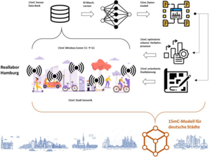
NGCN - Next Generation City Networking
Das Projekt "Next Generation City Networking" (NGCN) wird im Rahmen des Hamburg Wireless Innovation Competence Center (HAWICC) als Hamburger Außenstelle des Deutschen Zentrums Mobilität der Zukunft (DZM) Lösungsansätze für die Mobilität der Zukunft untersuchen, deren systemischer Ansatz eine innovative Funk- und Kommunikationsinfrastruktur mit einer daten- basierten Modellplattform für die 15-Minuten-Stadt und dem Anwendungsfall Notfallhilfe verbinden. Die in NGCN angelegte Nutzung von Wireless Innovations und die Nutzung neuer Data Lakes ver- bindet urbane IoT-Systeme und KI-Anwendungen im Sinne eines wegweisenden AIoT für Städte.
Ansprechpartner:
VisioChick
Das Projekt VisioChick wird im Rahmen der Modell- und Demonstrationsvorhaben Tierschutz gefördert und verfolgt das Ziel, Tierschutz und Tierwohl in der Geflügelhaltung durch ein innovatives Mixed-Reality (MR)-System und entsprechende Lehrmaterialien für verschiedene Zielgruppen attraktiver und praxisnäher zu gestalten. Durch den Einsatz von Virtual-Reality (VR)-Brillen und einer speziell entwickelten Software sollen Auszubildende, Lehrer und Studierende in die Lage versetzt werden, Tierschutz aus der Perspektive des Tieres zu erleben und zu verstehen. Das Projekt umfasst die Erstellung theoretischer Grundlagen, die Entwicklung und Erprobung des MR-Systems sowie eine Evaluation der Eignung des Systems für die Aus-, Fort- und Weiterbildung. Zum Abschluss wird die MR-Brille samt Lehrmaterialien als "Werkzeugkoffer" für interessierte Institutionen zur Verfügung gestellt, um den Wissenstransfer nachhaltig zu fördern. Das Projekt wird zwischen Universität Osnabrück, Universität Bonn und der HafenCity Universität Hamburg durchgeführt.

Ansprechpartner:
FPOplus - Smarte Daten für optimierte Personenströme
Das Projekt FPOplus befasst sich mit dem Aufbau eines Flowmanagement-Systems für Personenströme unter Einsatz innovativer Netztechnologien (5G) und findet im Rahmen einer Kooperation mit weiteren Universitäten und der Deutschen Bahn statt. Das Projekt wird vom VDI/VDE im Auftrag des Bundesministeriums für Digitales und Verkehr (BMDV) im Rahmen des Förderprogramms InnoNT betreut.
Ansprechpartner:


Kontakt & Informationen
Kontaktinformationen
Prof. Dr.-Ing. Youness Dehbi
youness.dehbi(at)hcu-hamburg.de
+49 40 428 27 - 5328
Raum 4.177 (4.183)
Henning-Voscherau-Platz 1
20457 Hamburg
Sprechstunde
Sprechstunde in der Vorlesungszeit:
Nach Vereinbarung