Prof. Dr.-Ing. Youness Dehbi
Teaching (summer)
- Informatik 2 (B.Sc. TGA)
- Sensornetzwerke und IoT (B.Sc.)
- Raumbezogene Datenanalyse (B.Sc.)
- Big Data Analytics (M.Sc.)
- Digitale Theorie / BIM (M.Sc. BIW)
Teaching (winter)
- Geodatenverwaltung und -analyse (B.Sc.)
- Grundlagen der Geoinformatik (B.Sc.)
- Geodateninfrastrukturen (B.Sc.)
- Mathematik 3 (B.Sc.)
- Informatik 3 (B.Sc.)
- Engineering Mathematics (M.Sc.)
- Ingenieurmathematik (M.Sc. BIW)
Vita
- since 03/2023:
Professor for Computational Methods at the HafenCity University Hamburg - 09/2016 to 02/2023:
Postdoctoral researcher in the geoinformation group at Institute of Geodesy and Geoinformation at University of Bonn - 08/2008 to 09/2016:
Scientific research assistant in the geoinformation group at Institute of Geodesy and Geoinformation at University of Bonn - 10/2003 bis 05/2008:
Study of Computer Science and communication resaearch at the university of Bonn
Awards
- 2023: "Best Paper Award in the Digital Construction: BIM Application Workshop, Geospatial Week, Cairo, Egypt"
- 2021: "Best Reviewer Award of the ISPRS Congress, Nice, France"
- 2019: "Best Paper Award at the 14th 3D GeoInfo Conference, Singapore"
- 2019: "Best Paper Award at the 4th International Conference on Smart Data and Smart Cities, Kuala Lumpur, Malaysia"
- 2018: "Best Paper Award at the 3rd International Conference on Smart Data and Smart Cities, Delft, Netherlands"
Committee work
Advisor of the International Society of Photogrammetry and Remote Sensing working group IV/9 (ISPRS WG IV/9)
"Spatially Enabled Urban and Regional Digital Twins" www2.isprs.org/commissions/comm4/wg9/
2026
W. Li, J. Zhu, Q. Zhu, J. Zhang, J. Wu,Y. Dehbi. Spatial Modelling for Bridge Construction Environment Towards Geospatial Digital Twin, 2026, International Journal of Applied Earth Observation and Geoinformation, (Accepted for publication).
L. Arzoumanidis, A. M. As Samee, E. Kanna, S. H. Nguyen, Y. Dehbi. Domain-Adaptive Object Detection for Enriching Semantic 3D City Models with Building Storeys from Street-View Images, ISPRS Ann. Photogramm. Remote Sens. Spatial Inf. Sci., 2026, Accepted for publication.
L. Arzoumanidis, W. Li, Y. Dehbi. Domain-Adaptive Object Detection of Electrical Facilities for Enhanced Semantic Indoor Models, ISPRS Ann. Photogramm. Remote Sens. Spatial Inf. Sci., 2026, Accepted for publication.
E. Kanna, J. Matijevic, L. Arzoumanidis, S. H. Nguyen, Y. Dehbi. Semantic Enrichment of 3D City Models via Roof-material Classification for Urban Greening and Heat Island Mitigation. 2026. preprint http://dx.doi.org/10.2139/ssrn.6127041
2025
L. Arzoumanidis, J. Knechtel, JH. Haunert, Y. Dehbi. Automatic Uncertainty-Aware Synthetic Data Bootstrapping for Historical Map Segmentation. arXiv preprint arXiv:2511.13742, 2025, https://doi.org/10.48550/arXiv.2511.15875
J. Hecht, W. Li, Z. Li, Y. Dehbi. Review of Passenger Flow Modeling Approaches Based on a Bibliometric Analysis. arXiv preprint arXiv:2511.13742, 2025, doi.org/10.48550/arXiv.2511.13742.
Li, W., Matijevic, J., Beil, C., Arzoumanidis, L., Kolbe, TH, & Dehbi, Y. (2025). Bidirectional enrichment of OpenStreetMap and CityGML 3.0 to facilitate cycling safety assessment. International Journal of Geographical Information Science, 1–24. https://doi.org/10.1080/13658816.2025.2595662
W. Li, J. Zhu, S. Pirasteh, Q. Zhu, Y. Guo, L. Luo, Y. Dehbi "A 3D virtual geographic environment for flood representation towards risk communication" arXiv preprint arXiv:2512.03839, 2025, http://doi.org/10.48550/arXiv.2512.03839
Y. Dehbi, E. Kanna, S. Koppers, L. Plümer. Using deformations of measuring noise distributions for the discrimination of 3d building model parts. Accepted for the Second Edition of the Mediterranean Smart Cities Conference (MSCC'2025)
Jaisawal, PK, Dehbi, Y. and Sternberg, H., 2025. Particle Filter-Based Indoor Localization with Learning Based PDR and Monocular Depth-Aided BIM Matching. IPIN-WCAL 2025 : Proceedings of the Workshop for Computing & Advanced Localization at the Fifteenth International Conference on Indoor Positioning and Indoor Navigation, September 15-18, 2025, Tampere, Finland. Conference Paper (Best Poster Award).
L. Arzoumanidis, SH Nguyen, L. Johannsen, F. Rothaut, W. Li, and Y. Dehbi: Object Detection for the Enrichment of Semantic 3D City Models with Roofing Materials, ISPRS Ann. Photogram. Remote Sens. Spatial Inf. Sci . ,
Knechtel J, Dehbi Y, Klingbeil L, Haunert JH. Simultaneous planning of standpoints and routing for laser scanning of buildings with network redundancy. ISPRS Journal of Photogrammetry and Remote Sensing. 2025 Jun 1;224:59-74.
Bolte AM, Kistemann T, Dehbi Y, Kötter T. (Un)just Distribution of Visible Green Spaces? A Socio-Economic Window View Analysis on Residential Buildings: The City of Cologne as Case Study. Journal of Geovisualization and Spatial Analysis. 2025 Jun;9(1):17.
D. Baltzer, S. Douglas, J.-H. Haunert, Y. Dehbi, I. Tiemann, Smart Glasses in the Chicken Barn: Enhancing Animal Welfare Through Mixed Reality, Smart Agricultural Technology, 2025
L. Arzoumanidis, J. Knechtel, J.-H. Haunert, and Y. Dehbi, 2025. Semantic Segmentation of Historical Maps using Self-Constructing Graph Convolutional Networks. Cartography and Geographic Information Science. doi.org/10.1080/15230406.2025.2468304 .
L. Arzoumanidis*, J. Knechtel*, G. Sen*, W. Li, & Y. Dehbi (2025). Rooftop Drainage Outlets and Ventilations Dataset. Automatic Detection of Tiny Drainage Outlets and Ventilations on Flat Rooftops from Aerial Imagery (GSW'2025), Dubai. doi.org/10.5281/zenodo.14040571 .
L. Arzoumanidis, W. Li, J. Knechtel, Y. Kosmayadi, Y. Dehbi, Automatic Detection of Tiny Drainage Outlets and Ventilations on Flat Rooftops from Aerial Imagery, ISPRS Ann. Photogram. Remote Sens . Spatial Inf. Sci . ,
A.-M. Bolte, T. Kistemann, T. Kötter, Y. Dehbi, Validating a window view simulation engine based on open data and open source using semantic segmentation, ISPRS GeoSpatial Week Dubai, Int. Arch. Photogram. Remote Sens. Spatial Inf. Sci., 2025
2024
W. Li, JH. Haunert, A. Forsch, J. Zhu, Q. Zhu, Y. Dehbi, Informed sampling and recommendation of cycling routes: leveraging crowd-sourced trajectories with weighted-latent Dirichlet allocation, International Journal of Geographical Information Science, 2024, 1-22, https://doi.org/10.1080/13658816.2024.2391428
J. Knechtel, P. Rottmann, JH. Haunert, Y. Dehbi, Semantic floor plan segmentation using self-constructing graph networks, Automation in Construction, Volume 166, 2024, 105649, ISSN 0926-5805, doi.org/10.1016/j.autcon.2024.105649.
Arzoumanidis L, Fethers JO, Mudiyanselage SH, Dehbi Y (2024). Deep Generation of Synthetic Training Data for the Automated Extraction of Semantic Knowledge from Historical Maps. Abstracts of the International Cartographic Association. EuroCarto (2024), Vienna, Austria. doi.org/10.5194/ica-abs-7-7-2024 .
W. Li, L. Arzoumanidis, J. Matijevic, D. Mohammed, P. Rottmann, J.-H. Haunert, & Y. Dehbi (2024). Safety assessment of cycling routes in urban environments. Int. Arch. Photogram. Remote Sens. Spatial Inf. Sci., XLVIII-4/W10-2024, 125–130, Smart Data and Smart Cities Conference, Athens, 2024. doi.org/10.5194/isprs-archives-XLVIII-4-W10-2024-125-2024 . ( Best Paper Award in the Smart People Category )
Arzoumanidis, L., Hecht, J., and Dehbi, Y.: Towards a Deep Automatic Generation of Figure-ground Maps, ISPRS Ann. Photogram. Remote Sens. Spatial Inf. Sci.,
Weilian Li, Jun Zhu, Saied Pirasteh, Qing Zhu, Yukun Guo, Lan Luo, Youness Dehbi, A 3D virtual geographic environment for flood representation towards risk communication, 2024, International Journal of Applied Earth Observation. https://doi.org/10.1016/j.jag.2024.103757
Weilian Li, Jun Zhu, Qing Zhu, Zhang Jinbin, Xiao Han, Youness Dehbi. Visual attention-guided augmented representation of geographic scenes: A case of bridge stress visualization, International Journal of Geographical Information Science, 1-23, 2024. https://doi.org/10.1080/13658816.2023.2301313
A. Bolte, B. Niedermann, T. Kistemann, J.-H. Haunert, Y. Dehbi and T. Kötter. The green window view index: automated multi-source visibility analysis for a multi-scale assessment of green window views. Landscape Ecology 39, 71 (2024). doi.org/10.1007/s10980-024-01871-7
2023
L. Arzoumanidis, A. Forsch, J.-H. Haunert and Y. Dehbi. Catchment cell visualization for multi-modal public transportation networks. 1st ACM SIGSPATIAL Workshop on Sustainable Mobility, Hamburg, 2023. https://dl.acm.org/doi/10.1145/3615899.3627931
J. M.-Lietzkow, C. Nataliya and Y. Dehbi. FPOPlus: Cutting-Edge Technology for Sustainable Future Mobility. 1st ACM SIGSPATIAL Workshop on Sustainable Mobility, 2024.
W. Li, J.-H. Haunert, J. Knechtel, J. Zhu, Q. Zhu, and Y. Dehbi. Social Media Insights on Public Perception and Sentiment During and After Disasters: The European Floods in 2021 as a Case Study. Transactions in GIS, 27(6):1766-1793, 2023. https://doi.org/10.1111/tgis.13097
J. Knechtel, W. Li, Y. Orgeig, J.-H. Haunert and Y. Dehbi. Immersive virtual reality to verify the as-built state of electric line networks in buildings. n: Kolbe, T.H., Donaubauer, A., Beil, C. (eds) Recent Advances in 3D Geoinformation Science. 3DGeoInfo 2023. Lecture Notes in Geoinformation and Cartography. Springer, Cham. doi.org/10.1007/978-3-031-43699-4_8
J. Knechtel, J. Behmann, J.-H. Haunert and Y. Dehbi. Suitability Assessment of Different Sensors to Detect Hidden Installations for As-built BIM. SUITABILITY ASSESSMENT OF DIFFERENT SENSORS TO DETECT HIDDEN INSTALLATIONS FOR AS-BUILT BIM, ISPRS Ann. Photogramm. Remote Sens. Spatial Inf. Sci., X-1/W1-2023, 263–270, doi.org/10.5194/isprs-annals-X-1-W1-2023-263-2023, 2023. (Best Paper Award in the Digital Construction: BIM Application Workshop)
W. Li, N. Treff, F. Amann, J. Lehmen, Y. Dehbi and J.-H. Haunert. AN INTERACTIVE EVACUATION TOOL TO IMPROVE THE PUBLIC FLOOD PERCEPTION, Int. Arch. Photogramm. Remote Sens. Spatial Inf. Sci., XLVIII-1/W2-2023, 437–442, doi.org/10.5194/isprs-archives-XLVIII-1-W2-2023-437-2023, 2023.
L. Arzoumanidis, J. Knechtel, J.-H. Haunert and Y. Dehbi. Self-Constructing Graph Convolutional Networks for Semantic Segmentation of Historical Maps. Abstracts of the International Cartographic Association, 6, 11, 2023. 31st International Cartographic Conference (ICC 2023), 13–18 August 2023, Cape Town, South Africa. doi.org/10.5194/ica-abs-6-11-2023.
W. Li, Y. Guo, J.-H. Haunert, Y. Dehbi. Integrating cellular automata model into 3D representation for enhancing flood risk communication. Abstracts of the International Cartographic Association, 6, 139, 2023. 31st International Cartographic Conference (ICC 2023), 13–18 August 2023, Cape Town, South Africa. doi.org/10.5194/ica-abs-6-139-2023.
2022
Y. Dehbi, J. Knechtel, B. Niedermann, and J.-H. Haunert. Incremental constraint-based reasoning for estimating as-built electric line routing in buildings. Automation in Construction, 143:104571, 2022. https://doi.org/10.1016/j.autcon.2022.104571
L. Weilian, Z. Jun, J.-H. Haunert, F. Lin, Z. Qing, and Y. Dehbi. Three-dimensional virtual representation for the whole process of dam-break floods from a geospatial storytelling perspective. International Journal of Digital Earth, 15:1637-1656, 2022. https://doi.org/10.1080/17538947.2022.2118877
P. Rottmann, J.-H. Haunert, and Y. Dehbi. Automatic building footprint extraction from 3d laserscans. ISPRS Annals of the Photogrammetry, Remote Sensing and Spatial Information Sciences, X-4/W2-2022:233-240, 2022. https://isprs-annals.copernicus.org/articles/X-4-W2-2022/233/2022/
Victor Korir, Axel Forsch, Youness Dehbi, and Jan-Henrik Haunert. Visualizing the modal split in public transportation networks. Abstracts of the ICA, 5:89, sep 2022.
J. Knechtel, L. Klingbeil, J.-H. Haunert, and Y. Dehbi. Optimal position and path planning for stop-and-go laserscanning for the acquisition of 3d building models. ISPRS Annals of the Photogrammetry, Remote Sensing and Spatial Information Sciences, V-4-2022:129-136, 2022. https://isprs-annals.copernicus.org/articles/V-4-2022/129/2022/
W. Li, J. Zhu, S. Pirasteh, Q. Zhu, L. Fu, J. Wu, Y. Hu, and Y. Dehbi. Investigations of disaster information representation from a geospatial perspective: progress, challenges and recommendations. Transactions in GIS, 26(3):1376-1398, 2022. https://doi.org/10.1111/tgis.12922
Barramou, Fatimazahra, Khalifa Mansouri, and Youness Dehbi, eds. Geospatial Intelligence: Applications and Future Trends. Springer International Publishing, 2022.
2021
Youness Dehbi, Johannes Leonhardt, Johannes Oehrlein, and Jan-Henrik Haunert. Optimal scan planning with enforced network connectivity for the acquisition of three-dimensional indoor models. ISPRS Journal of Photogrammetry and Remote Sensing, 180:103-116, 2021. https://doi.org/10.1016/j.isprsjprs.2021.07.013
L. Lucks, L. Klingbeil, L. Plümer, and Y. Dehbi. Improving trajectory estimation using 3d city models and kinematic point clouds. Transactions in GIS, 25(1):238-260, 2021. https://doi.org/10.1111/tgis.12719
Y. Dehbi, A. Henn, G. Gröger, V. Stroh, and L. Plümer. Robust and fast reconstruction of complex roofs with active sampling from 3d point clouds. Transactions in GIS, 25(1):112-133, 2021. https://doi.org/10.1111/tgis.12659
Y. Dehbi, S. Koppers, and L. Plümer. Looking for a needle in a haystack: probability density based classification and reconstruction of dormers from 3d point clouds. Transactions in GIS, 25(1):44-70, 2021. https://doi.org/10.1111/tgis.12658
Axel Forsch, Youness Dehbi, Benjamin Niedermann, Johannes Oehrlein, Peter Rottmann, and Jan-Henrik Haunert. Multimodal travel-time maps with formally correct and schematic isochrones. Transactions in GIS, 25(6):3233-3256, 2021. https://doi.org/10.1111/tgis.12821
2020
Y. Dehbi, L. Klingbeil, and L. Plümer. Uav mission planning for automatic exploration and semantic mapping. ISPRS - International Archives of the Photogrammetry, Remote Sensing and Spatial Information Sciences, XLIII-B1-2020:521-526, 2020
2019
Y. Dehbi, A. Henn, G. Gröger, V. Stroh, and L. Plümer. Active sampling and model based prediction for fast and robust detection and reconstruction of complex roofs in 3d point clouds. In volume IV-4/W8 of ISPRS Annals of the Photogrammetry, Remote Sensing and Spatial Information Sciences. Proc. 14th 3D Geoinfo Conference, pages 43-50. 2019. (Best Paper Award)
F. Biljecki, and Y. Dehbi. Raise the roof: towards generating lod2 models without aerial surveys using machine learning. In volume IV-4/W8 of ISPRS Annals of the Photogrammetry, Remote Sensing and Spatial Information Sciences. Proc. 14th 3D Geoinfo Conference, pages 27-34. 2019.
Y. Dehbi, S. Koppers, and L. Plümer. Probability density based classification and reconstruction of roof structures from 3d point clouds. In volume XLII-4/W16 of ISPRS - International Archives of the Photogrammetry, Remote Sensing and Spatial Information Sciences. Proc. 6th International Conference on Geomatics and Geospatial Technology, pages 177-184. 2019.
Y. Dehbi, L. Lucks, J. Behmann, L. klingbeil, and L. Plümer. Improving gps trajectories using 3d city models and kinematic point clouds. In volume IV-4/W9 of ISPRS Annals of the Photogrammetry, Remote Sensing and Spatial Information Sciences. Proc. 4th International Conference on Smart Data and Smart Cities, pages 35-42. 2019. (Best Paper Award)
2018
J. Oehrlein, A. Förster, D. Schunck, Y. Dehbi, R. Roscher, and J.-H. Haunert. Inferring routing preferences of bicyclists from sparse sets of trajectories. In volume IV-4/W7 of ISPRS Annals of the Photogrammetry, Remote Sensing and Spatial Information Sciences. Proc. 3rd International Conference on Smart Data and Smart Cities, pages 107-114. 2018. ( Best Paper Award )
Y. Dehbi, N. Gojayeva, AR Pickert, J.-H. Haunert, and L. Plümer. Room shapes and functional uses predicted from sparse data. In volume IV-4:33-40 of ISPRS Annals of the Photogrammetry, Remote Sensing and Spatial Information Sciences. Proc. ISPRS Technical Commission IV Symposium. 2018.
2017
Y. Dehbi, J.-H. Haunert, and L. Plümer. Stochastic and geometric reasoning for indoor building models with electrical installations - bridging the gap between gis and bim. In volume IV-4/W5 of ISPRS Annals of Photogrammetry, Remote Sensing and Spatial Information Sciences. Proc. 12th 3D Geoinfo Conference, pages 33-39. 2017.
Y. Dehbi, S. Loch-Dehbi, and L. Plümer. Parameter estimation and model selection for indoor models based on sparse observations. In volume IV-2/W4 of ISPRS Annals of Photogrammetry, Remote Sensing and Spatial Information Sciences. Proc. ISPRS Geospatial Week 2017, pages 303-310. 2017.
Y. Dehbi, F. Hadiji, Gerhard Gröger, Kristian Kersting, and L. Plümer. Statistical relational learning of grammar rules for 3d building reconstruction. Transactions in GIS, 21(1):134-150, 2017. https://doi.org/10.1111/tgis.12200
S. Loch-Dehbi, Y. Dehbi, and L. Plümer. Estimation of 3d indoor models with constraint propagation and stochastic reasoning in the absence of indoor measurements. ISPRS International Journal of Geo-Information, 6(3), 2017.
2016
Y. Dehbi, Gerhard Gröger, and L. Plümer. Identification and modeling of translational and axial symmetries and their hierarchical structures in building footprints by formal grammars. Transactions in GIS, 20(5):645-663, 2016. https://doi.org/10.1111/tgis.12177
Y. Dehbi. Statistical relational learning of semantic models and grammar rules for 3D building reconstruction from 3D point clouds. University and State Library Bonn. University of Bonn, Germany, 2016. Dissertation.
Y Dehbi, C Staat, L Mandtler, and L Plümer. Incremental refinement of facade models with attribute grammar from 3d point clouds. In volume III-3 of ISPRS Annals of Photogrammetry, Remote Sensing and Spatial Information Sciences. Proc. XXIII ISPRS Congress, pages 311-316. 2016.
S. Loch-Dehbi, Y. Dehbi, G. Gröger, and L. Plümer. Prediction of building floorplans using logical and stochastic reasoning based on sparse observations. In volume IV-2/W1 of ISPRS Annals of Photogrammetry, Remote Sensing and Spatial Information Sciences. Proc. 11th 3D Geoinfo Conference, pages 265-270. 2016.
2013
S. Loch-Dehbi, Y. Dehbi, and L. Plümer. Stochastic reasoning for uav supported reconstruction of 3d building models. In volume XL-1/W2 of ISPRS Annals of Photogrammetry, Remote Sensing and Spatial Information Sciences. Proc. UAV-g Conference 2013, pages 257-261. 2013.
2011
Y. Dehbi, and L. Plümer. Learning grammar rules of building parts from precise models and noisy observations. ISPRS Journal of Photogrammetry and Remote Sensing, 66(2):166-6176, 2011. Quality, Scale and Analysis Aspects of Urban City Models. https://doi.org/10.1016/j.isprsjprs.2010.10.001
2010
Y. Dehbi, Jörg Schmittwilken, and L. Plümer. Learning semantic models and grammar rules of building parts. In Proc. 24th Workshop on Constraint Logic Programming (WLP 2010), pages 45-56. German University in Cairo, 2010.
2009
Y. Dehbi, Jörg Schmittwilken, and L. Plümer. Learning semantic models and grammar rules of building parts. In volume XXXVIII-2/W11 of ISPRS Archives of Photogrammetry, Remote Sensing and Spatial Information Sciences. Proc. of the ISPRS WG II/2+3+4 and Cost Workshop. Lund, Sweden 2009. 2009.
Lukas Arzoumanidis, M.Sc.

lukas.arzoumanidis(at)hcu-hamburg.de
+49 04300880 - 5360
Room: 4.178 (4.183)
Henning-Voscherau-Platz 1
20457 Hamburg
Dr. rer. nat. Son H. Nguyen
son.nguyen(at)hcu-hamburg.de
+49 040 300 880 - 2797
Raum: 4.182
Henning-Voscherau-Platz 1
20457 Hamburg
Vita
- since 01/2025: Postdoc (Dr. rer. nat.), specialized in Knowledge Graphs and Efficient Algorithms, at the HafenCity University Hamburg, Computational Methods Lab (Prof. Youness Dehbi)
- 06/2017 - 12/2024: Research Associate and PhD Candidate, specialized in Graph-based Detection and Interpretation of Changes in Massive Semantic 3D City Models, at the Technical University of Munich, TUM School of Engineering and Design, Department of Aerospace and Geodesy, Chair of Geoinformatics (Prof. Thomas H. Kolbe)
- 10/2014 - 05/2017: M.Sc. in Informatics (specialized in Robotics and Geoinformatics) at the Technical University of Munich, Deparment of Informatics
- 10/2011 - 09/2014: B.Sc. in Informatics (specialized in Mathematics and Autonomous Driving) at the Technical University of Munich, Department of Informatics
- 09/2010 - 09/2011: Studienkolleg (MINT/STEM Courses) Munich
- 09/2009 - 08/2010: B.Sc. in Informatics at the Ho Chi Minh City University of Technology
- 09/2006 - 08/2009: Le Hong Phong Highschool for the Gifted (specialized in Physics), Ho Chi Minh City, Vietnam
Awards
- 2025: Best Dissertation and Best PhD Presentation, Förderpreise Runder Tisch GIS e.V. 2025, Technical University of Munich
- 2024: Highest Distinction summa cum laude, Dissertation "Automatic Detection and Interpretation of Changes in Massive Semantic 3D City Models", Technical University of Munich
- 2024: Honors for Exceptional Achievements in Research and Teaching at the Technical University of Munich
- 2023: Honors for Exceptional Achievements in Research and Teaching at the Technical University of Munich
- 2022: Best Young Researcher Paper Award, at the Conference 3D GeoInfo 2022 in University of New South Wales in Sydney, Australia, Article "Path-tracing Semantic Networks to Interpret Changes in Semantic 3D City Models", Authors: Son H. Nguyen, Thomas H. Kolbe
- 2021: Outstanding Paper Award, at the Online-Konferenz 3D GeoInfo 2021 in New York University in New York City, USA, Article "Modelling Changes, Stakeholders and their Relations in Semantic 3D City Models", Authors: Son H. Nguyen, Thomas H. Kolbe, Track: 3D City Modelling
- 2020: Excellent Teaching, Best Exercise Course in "Project Work in Geoinformatics" (Winter Term 2019/2020), Technical University of Munich, Student Council of the Department of Aerospace and Geodesy
- 2020: Excellent Teaching, Best Exercise Course in "Introduction to Computer Science 2 (Exercise)" (Summer Term 2020), Technical University of Munich, Student Council of the Department of Aerospace and Geodesy
2024
Nguyen, Son H.: Automatic Detection and Interpretation of Changes in Massive Semantic 3D City Models. Dissertation, 2024. URL.
Olbrich, Felix; Beil, Christof; Nguyen, Son H.; Kolbe, Thomas H.: Multimodale Navigationsanwendungen für CityGML 3.0-konforme 3D-Straßenraummodelle mittels Graphdatenbanken. 44. Wissenschaftlich-Technische Jahrestagung der DGPF in Remagen – Publikationen der DGPF, Deutsche Gesellschaft für Photogrammetrie, Fernerkundung und Geoinformation e.V., 2024, 357-369. URL.
2023
Nguyen, Son H.; Kolbe, Thomas H.: Identification and Interpretation of Change Patterns in Semantic 3D City Models. Lecture Notes in Geoinformation and Cartography - Recent Advances in 3D Geoinformation Science - Proceedings of the 18th 3D GeoInfo Conference, Springer, 2023. doi.org/doi:10.1007/978-3-031-43699-4_30.
2022
Nguyen, Son H.; Kolbe, Thomas H.: Path-tracing Semantic Networks to Interpret Changes in Semantic 3D City Models. Proceedings of the 17th International 3D GeoInfo Conference 2022 (ISPRS Annals of the Photogrammetry, Remote Sensing and Spatial Information Sciences), ISPRS, 2022. doi.org/10.5194/isprs-annals-X-4-W2-2022-217-2022.
2021
Beil, Christof; Dimitrov, Hristiyan; Dong, Zeyu; Kavelj, Nikola; Khalil, Carine; Kutzner, Tatjana; Müller, Felix; Nguyen, Son H.; Wysocki, Olaf: INTERGEO DIGITAL 2020 - Trendanalyse. zfv - Zeitschrift für Geodäsie, Geoinformation und Landmanagement 146 (1), 2021, 64-70.
Beil, Christof; Dimitrov, Hristiyan; Dong, Zeyu; Kavelj, Nikola; Khalil, Carine; Kutzner, Tatjana; Müller, Felix; Nguyen, Son H.; Wysocki, Olaf: Trendanalyse Intergeo Digital 2020. gis.Business (1), 2021, 46-49.
Nguyen, Son H.; Kolbe, Thomas H.: Modelling Changes, Stakeholders and their Relations in Semantic 3D City Models. Proceedings of the 16th International 3D GeoInfo Conference 2021 (ISPRS Annals of the Photogrammetry, Remote Sensing and Spatial Information Sciences), ISPRS, 2021, 137-144. doi.org/10.5194/isprs-annals-VIII-4-W2-2021-137-2021.
2020
Nguyen, Son H.; Kolbe, Thomas H.: A Multi-Perspective Approach to Interpreting Spatio-Semantic Changes of Large 3D City Models in CityGML using a Graph Database. Proceedings of the 15th International 3D GeoInfo Conference 2020 (ISPRS Annals of the Photogrammetry, Remote Sensing and Spatial Information Sciences), ISPRS, 2020, 143–150. doi.org/10.5194/isprs-annals-VI-4-W1-2020-143-2020.
2019
Angermann, Lucas; Donaubauer, Andreas; Graw, Katharina; Holtkamp, Jonathan; Huber, Tobias; Nguyen, Son H.; Schwab, Benedikt; Wysocki, Olaf: INTERGEO 2019 TREND ANALYSIS. HINTE Messe- und Ausstellungs-GmbH, 2019. URL.
Angermann, Lucas; Donaubauer, Andreas; Graw, Katharina; Holtkamp, Jonathan; Huber, Tobias; Nguyen, Son H.; Schwab, Benedikt; Wysocki, Olaf: Und jährlich grüßt die INTERGEO. zfv - Zeitschrift für Geodäsie, Geoinformation und Landmanagement 144 (6), 2019.
Chaturvedi, Kanishk; Matheus, Andreas, Nguyen, Son H., Kolbe, Thomas H.: Securing Spatial Data Infrastructures For Distributed Smart City Applications and Services. Future Generation Computer Systems 101 (Special Issue on Security & Biometrics), 2019. doi.org/10.1016/j.future.2019.07.002.
2018
Chaturvedi, Kanishk; Matheus, Andreas; Nguyen, Son H.; Kolbe, Thomas H.: Securing Spatial Data Infrastructures in the Context of Smart Cities. 2018 International Conference on CYBERWORLDS (CW 2018), 2018, 403-408. doi.org/10.1109/CW.2018.00078.
Marx, Caroline; Schwab, Benedikt; Nguyen, Son H.; ElFouly, Mostafa; Angermann, Lucas; Hotschek, Alexander; Kammel, Frederik; Lauterbach, Roswitha; Lechner, Katharina; Zagst, Sabine: Trendanalyse InterGEO 2018. zfv - Zeitschrift für Geodäsie, Geoinformation und Landmanagement 143 (6), 2018. URL.
Nguyen, Son H.; Yao, Zhihang; Kolbe, Thomas H.: Spatio-Semantic Comparison of Large 3D City Models in CityGML Using a Graph Database. gis.Science (3/2018), 2018, 85-100. URL.
2017
Nguyen, Son H.: Spatio-semantic Comparison of 3D City Models in CityGML using a Graph Database. Masterarbeit, 2017. URL.
Nguyen, Son H.; Yao, Zhihang; Kolbe, Thomas H.: Spatio-Semantic Comparison of Large 3D City Models in CityGML Using a Graph Database. Proceedings of the 12th International 3D GeoInfo Conference 2017 (ISPRS Annals of the Photogrammetry, Remote Sensing and Spatial Information Sciences), ISPRS, 2017, 99-106. doi.org/10.5194/isprs-annals-iv-4-w5-99-2017.
2016
Nguyen, Son H.: Model-driven General Indicator Modelling exemplified by the Building Thermal Energy Assessment Standard DIN 18599-2. IDP-Arbeit, 2016.
Elmehdi Kanna, M.Sc.

elmehdi.kanna@hcu-hamburg.de
+49 1523 9553408
Room: 4.181 (4.183)
Henning-Voscherau-Platz 1
20457 Hamburg
- since 06/2025: Research Associate & PhD Candidate, specialized in Next-Generation City Networking, AI-driven Urban Systems, and Digital Twins, at the HafenCity University Hamburg
- 11/2022 - 06/2025: Software Development Team Manager at EngiMA, Casablanca, leading VR/AR application development and managing large-scale BIM projects from concept to implementation.
- 04/2022 - 11/2022: Software Engineer Intern at EngiMA, specializing in the integration of IoT and AI for smart buildings, and developing VR applications for digital twin projects.
- 2019 - 2022: M.S. in General Engineering (specialized in Computer Science) at Ecole Centrale Casablanca
- 2017 - 2019: Intensive Preparatory Classes (Degree in Physics, Technology, Industrial Science), Agadir
2026
Kanna, Elmehdi; Matijevic, Jannik; Arzoumanidis, Lukas; Nguyen, Son H.; Dehbi, Youness. Semantic Enrichment of 3D City Models via Roof-material Classification for Urban Greening and Heat Island Mitigation. http://dx.doi.org/10.2139/ssrn.6127041
Ouzougarh Badreddine, M.Sc.

badred-edine.ouzougarh@hcu-hamburg.de
+49 1715278819
Room: 4.181 (4.180)
Henning-Voscherau-Platz 1
20457 Hamburg
- since 06/2025: Research Associate at HafenCity University Hamburg, working on the "Next Generation City Network (NGCN)" project, tackling 15-minute city mobility challenges
- 2024: Research Intern at Aalto University, Finland, working on "Digital Twins for Construction Management" to enhance construction workflows
- 2024: Aalto Science Institute (AScI) International Summer Research Programme at Aalto University
- 2023 - 2024: Research Intern at UM6P, Morocco, researching "Semantic 3D City Models" for urban performance analysis
- 2019 - 2024: M.Sc. in Geomatic Sciences at IAV Hassan II, Thesis: "Green Twin City: Urban Digital Twin for Benguerir"
Assoc. Prof. Dr. Weilian Li

- seit 01/2025:
Assoc. Prof. an der Faculty of Geosciences and Environmental Engineering, Southwest Jiaotong University, China - 11/2023 bis 12/2024:
Wissenschaftlicher Mitarbeiter und Postdoktorand an der HafenCity Universität Hamburg, Computational Methods - 10/2021 bis 10/2023:
Wissenschaftlicher Mitarbeiter und Postdoktorand am Institut für Geodäsie und Geoinformation, Universität Bonn - 02/2021 bis 07/2021:
Wissenschaftlicher Mitarbeiter und Postdoktorand am Lab for Geoinformatics and Geovisualization (g2lab), HafenCity Universität Hamburg - 01/2021 bis 02/2021:
Wissenschaftlicher Mitarbeiter und Postdoktorand an der Faculty of Geosciences and Environmental Engineering, Southwest Jiaotong University, China - 09/2015 bis 12/2020:
Wissenschaftlicher Mitarbeiter und Doktorand an der Faculty of Geosciences and Environmental Engineering, Southwest Jiaotong University, China
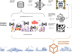
NGCN - Next Generation City Networking
The "Next Generation City Networking" (NGCN) project, part of the Hamburg Wireless Innovation Competence Center (HAWICC) and the Hamburg branch of the German Center for Mobility of the Future (DZM), will explore solutions for the mobility of the future. Its systemic approach integrates an innovative wireless and communication infrastructure with a data-driven model platform for the 15-minute city and the emergency assistance use case. NGCN's utilization of wireless innovations and new data lakes connects urban IoT systems and AI applications, paving the way for a groundbreaking AIoT for cities.
Contact:
VisioChick
The VisioChick project is funded as part of the Model and Demonstration Projects for Animal Welfare and aims to enhance animal welfare in poultry farming through an innovative Mixed Reality (MR) system and corresponding educational materials, making the topic more engaging and practical for various target groups. By using Virtual Reality (VR) headsets and specially developed software, trainees, teachers, and students will be able to experience and understand animal welfare from the perspective of the animals. The project includes the development of theoretical foundations, the design and testing of the MR system, and an evaluation of its suitability for vocational training, further education, and academic studies. At the conclusion of the project, the MR headset, along with the educational materials, will be provided as a "toolkit" to interested institutions to promote sustainable knowledge transfer. The project is being conducted by the University of Osnabrück, the University of Bonn, and the HafenCity University Hamburg.

Contact:
FPOplus - Smart Data for Optimized Passenger Flow
This project FPOplus deals with the development of a flow management system for passenger flows using innovative network technologies (5G) and is taking place as part of a cooperation with other universities and Deutsche Bahn. The project is being supervised by the VDI/VDE on behalf of the Federal Ministry for Digital and Transport (BMDV) as part of the InnoNT funding programme.

Contact:


Contactinformation
Prof. Dr.-Ing. Youness Dehbi
youness.dehbi(at)hcu-hamburg.de
+49 40 428 27 - 5328
Room 4.031
Henning-Voscherau-Platz 1
20457 Hamburg