Neuigkeiten | News

June 2014 | Castellón Spain

Alenka and Eszter at the AGILE Conference on Geographic Information Science

Tóth, E. and Poplin, A. 2014. <link file:7135 partici pecs agile2014>ParticiPécs – a cooperative game fostering learning about the built environment and urban planning, 17th AGILE Conference on Geographic Information Science (AGILE 2014), Workshop Geogames and Geoplay, Castellón, Spain.

Vemuri, K., Poplin, A. and Monachesi, P. 2014. YouPlaceIt!: a Serious Digital Game for Achieving Consensus in Urban Planning, 17th AGILE Conference on Geographic Information Science (AGILE 2014), Workshop Geogames and Geoplay, Castellón, Spain.


Some impressions...

May 2014| Vienna

Bärbel presented our paper at the CORP Conference in Vienna

Reinart, B. and Poplin, A. 2014. <link file:7242 reinart poplin paper games in urban>Games in urban planning – a comparative study, in the proceedings of Real CORP 2014, International Conference on Urban Planning and Regional Development in the Information Society (CORP 2014), Vienna, Austria.

Hamburg | Germany

GeoGames can change the way you participate in urban planning!

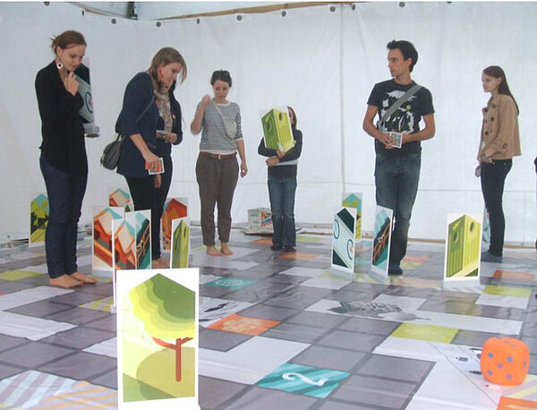
GeoGames are participatory games for urban planning that complement and optimize the conventional process of public participation. They offer the advantage to address important development issues in a playful way. Making the process of participation enjoyable in form of a game is an innovative way to incite residents and other interested citizens to take an active role in the plan making process. With GeoGames, you receive a tool to show and discuss your ideas in a creative way.

GeoGames offer the following advantages:

  • They can engage, animate and attract citizens with their playful and fun concepts
  • They are designed to attract many citizens in urban planning  processes
  • They revolutionize the design of public participatory processes in urban planning
  • They can be offered online, anytime, anyplace and are easily accessible for everybody with an internet access
  • They are intuitive, easy to be played by all age groups and can be  developed in different languages.

“playful and creative – inclusive  – informative”

 See us on www.geogameslab.de

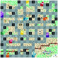
Our new game ParticiPécs

ParticiPécs aims to teach children about sustainable urban planning and participation in urban planning. It is a cooperative game and was developed in a serious of workshops together with children. Our first tests of this game were conducted in the city of Pécs, in Hungary. We feel excited about our new game! More to come!

Like us on facebook!

November 2013 | Hamburg, Germany

Congratulations...

to Stella Geyer for her bachelor thesis!
Advisors: A. Poplin and B. Reinart

August 2012| Redlands, California

Congratulations ...

 to Clara Thomas - she succesfully completed her BA in Urban Planning!

March 2013 | Cambridge USA

Eszter and Alenka presented their paper at the CORP conference 2013 in Rome

Eszter and Alenka presented the interactive participatory planning game "Po-up-Pest" at the CORP conference in Rome May 2013 (www.corp.at). The game, developed by Eszter Tóth, aims to encourage children to participate in urban planning processes. It is placed in Budapest and has been already played several times with young people of different age groups. The article summarizes the goals of the game and the first empirical results gained in the test-playing exercises.

March 2013 | Cambridge USA

Alenka presented an Example of the B3 Serious Game at the Harvard Kennedy School and the MIT Institute for Urban Planning, Cambridge, Massachusetts, USA

Alenka just returned from Harvard and MIT, where she presented our research on digital games and civic engagement. She worked with the Ash Centre for Governance and Innovation at the Harvard Kennedy School and became a Democracy Fellow (2013) in the team led by Prof. Archon Fung. On March 15th she presented our research on playful public participation in urban planning to the group of democracy fellows led by Prof. Fung. The title of her presentation was: Serious Games for Urban Planning: Example of the B3 Game. Thank you all for the valuable comments on the presentation and thank you too Prof. Archon Fung and your team for the great hospitality. On March 20th she presented our research at the MIT Urban Planning, MIT Scheller Teacher Education Program, The Education Arcade MIT in the group of Prof. Eric Klopfer (http://education.mit.edu/people/eric-klopfer) and Dr. Scot Osterweil (http://education.mit.edu/people/scot-osterweil). The title of her presentation was: Digital Serious Games for Civic Engagement in Urban Planning: Example of the B3 Game. Prof. Klopfer presented the activities of his research group and their internal organizational structure. Very interesting! Thank you! Here are some impressions from this event.

Alenka also had several very inspiring discussions with Dr. Konstantin Mitgutsch (MIT Game Lab). He is one of the main organizers of the 7th Vienna Games Conference - FROG13  in Vienna.  Alenka joined the program committee of this conference. Follow us on the website: http://bupp.at/en/service-en/frog/frog-2013/.

During her stay at the Harvard Kennedy School she also met Prof. Eric Gordon, with whom she has similar research interests. He is managing the Engagement Game Lab (http://engagementgamelab.org/ ) and has been successful in promoting games and game-based participation in urban planning. She discussed the use of different tools for public participation with Prof. Ann Forsyth, Professor of Urban Planning and Director of the Masters in Urban Planning Degree Program at Harvard Graduate School of Design (http://www.gsd.harvard.edu/#/people/ann-forsyth.html).

January 31- 2013 | Hamburg

KLIMZUG-Nord metadata collection workshop

To ease the data search in the project, support the data sharing among the project partners, as well as to increase the awareness of our research results to the potential users, we provide the metadata catalogue services Medais for the Klimzug-Nord project. This service supports easy data search function and detailed description of geo-referenced data. Recently we finished the new version of this platform.

Getting high quality metadata for our service is essential to make the service more powerful. For this purpose,we sincerely invite you to the Klimzug-Nord metadata collection workshop on 31.01.2013 at the HafenCity University Hamburg. It will be hold from10:30-16:30 in the Room A111 at the City Nord Campus (Hebebrandstrasse 1, D-22297). The work shop includes the following content:

· Introduction to the data exchange platform Medais: benefits and functions

· Medais tutorial and user test

· Klimzug-Nord metadata collection

August 2012| Redlands, California

Congratulation ...

.... to Tony Haertling for the completion of his bachelor thesis "Hamburg Heights: Skyscrapers in a multicultural district".

August 2012| Redlands, California

ArcGIS for AutoCAD

The latest release of ArcGIS for AutoCAD, Esri's free AutoCAD plug-in, improves the ability to exchange data and information between the ArcGIS and AutoCAD platforms. ArcGIS for AutoCAD users with read/write access to ArcGIS for Server feature services can now edit geodatabases through AutoCAD. This enables easier data dissemination between CAD and GIS users across the enterprise, reduces the duplication of work, and increases efficiency.

CAD professionals can use the free downloadable application to add, create, and edit GIS data within AutoCAD drawings. For example, users can add maps and map services from enterprise or cloud servers, such as ArcGIS Online, to their drawings, giving the design a geographic context and a common operating picture for the organization.

"ArcGIS for AutoCAD is the interface to the ArcGIS system and all of its rich data content, sharing, and data management," states Esri CAD product manager Don Kuehne. "The possibilities presented by the combination of AutoCAD and ArcGIS services to automate editing and data maintenance workflows are going to result in an exponential leap in value for those who take advantage of them."

The new release also includes access to image services and a geolocation service for navigating within an AutoCAD drawing. AutoCAD 2010/2011/2012 (32-bit and 64-bit) systems are supported. To learn more about or to download the new release of ArcGIS for AutoCAD, visit esri.com/autocadapp.

Originalquelle: spatialnews.geocomm.com/dailynews/2012/aug/23/news4.html


October 2011 - Februar 2012| Hamburg

M1 Project Results

Im Rahmen eines M1-Studienprojekts an der HafenCity Universität Hamburg beschäftigte sich die Projektgruppe mit den Themen „Online Partizipation“ und „Studierendenwohnheime in der Planung“. Im Verlauf eines Semesters haben Sie sich diesen Themen auf unterschiedliche Weise angenähert und als Konzept ein Tool zur spielerischen Beteiligung entwickelt. Weitere Informationen können unter http://www.sowillichleben.com/ abegrufen werden.


July 24 - August 08, 2011 | Cagliari

International Summer School 2011

We successfully completed the INFOPlan summer school in collaboration with the University of Cagliari and the University Collage Dublin. Thank you to all for the unforgettable moments! See you at our next summer school!


July 11 - 13, 2011 | Ispra

Workshop on the Socioeconomic Benefits from the Use of Earth Observations

Alenka attended the Workshop on the Socioeconomic Benefits from the Use of Earth Observations, 11-13 July 2011, Joint Research Centre, Ispra, Italy. The workshop was organised by JRC European Comission, NASA, IIASA and IEEE.


May 30th, 2011 | 14:00 | Room D102 (CityNord)

Francis Harvey (University of Minnesota)

The DigitalCity Research Group invites you to a very interesting talk on the value of geo data sharing.

The Titel of the talk is "Free Data and Free GIS : Some Observations from Minnesota", presented by Francis Harvey (University of Minnesota).

Further information.


Sept. 30th - Oct. 2nd 2010 | Hamburg

GeoValue 2010

We successfully held our workshop! Thank you to the participants for all interesting contributions and discussions.

The presentation are available on the workshop website www.geo-value.net.

September 2010 | Salvador, Bahia, Brasil

Alenka Poplin attended an international colloquium in Salvador, Brasil

International Colloquium on Democracy & Digital Interfaces for Public Participation
Projeto 2i2p – Internet e Interatividade para a Participação Pública
Sept. 2-3, 2010, Salvador, Bahia, Brasil

Slide show of the colloquium...

Invited presentation:
Poplin, A. 2010. Public Participation 2.0 (in Europe): Visions and Study Cases, International Colloquium on Democracy & Digital Interfaces for Public Participation, organized by Universidade Federal da Bahia (UFBA), September 2-3, 2010, Salvador, Bahia, Brasil.

August 2010 | Lausanne

eGov and ePart 2010

Beate Weninger attended the PhD colloquium!
more about eGov...
more about ePart...

July 2010 | Congratultions...

... to Jan Thomas on his Bachelor!

July 2010 | Machen Sie mit: Untersuchung zur Nutzung der Wilhelmsburger Gewässer

WILHELMSBURG AM WASSER

Gehen Sie an den Wilhelmsburger Gewässern spazieren, joggen oder grillen? Ist es Ihnen ein Anliegen, dass Sie das auch weiterhin machen können? Oder haben Sie andere Ideen wie Sie Ihre Freizeit an den Wilhelmsburger Gewässern verbringen können?

Dazu startet die HafenCity Universität Hamburg im Rahmen des weltweiten Forschungsprojektes Switch eine Online-Untersuchung.  Es soll herausgefunden werden, wie und wo die Wilhelmsburger Gewässer von der Bevölkerung zu Freizeitzwecken genutzt werden. Ziel ist es, eine Diskussionsgrundlage über die Nutzungsansprüche und den Naturschutz zu schaffen und am Ende eine Karte zu entwickeln, die dieses Konfliktfeld in Wilhelmsburg thematisiert.

Seien Sie dabei und bestimmen Sie mit!

www.wilhelmsburgamwasser.de

June 2010 | Cagliari, Sardinia

International Summer Workshop on Scenario Analysis in Urban and Regional Planning

The International Summer Workshop on Scenario Analysis in Urban and Regional Planning was jointly organised by the University of Cagliari (UniCA) and the HafenCity University of Hamburg (HCU).

The workshop was held in Cagliari (and Baunei)  from June 25 to July 3, 2010

The workshop program included a core multi-session training exercise on Scenario Analysis in Urban and Regional Planning for the students of the partner Universities, thematic seminars on spatial planning, and complementary scientific and socio-cultural activities fostering the exchange among participants.

The International Workshop official language was English

Chairpersons:  Prof. Michele Campagna, UniCA, and Prof. Alenka Poplin, HCU

Scientific Committee: Prof. Emanuela Abis, Prof. Giovanni Maria Campus, Prof. Anna Maria Colavitti, Prof. Andrea De Montis, Prof. Renato Troffa, Prof. Corrado Zoppi

Lead Instructors: Dr. Simone Caschili, Dr. Yuri Iannuzzi

Download the program.

June 2010 |  HafenCity University

Dr. Christoph Hölscher:  Orientierung und Navigation in komplexen Gebäuden

Oft ist es für den Besucher eines großen öffentlichen Gebäudes nicht leicht,  sich darin zu orientieren
und den Weg zum gewünschten Ziel zu finden. Im Sonderforschungsbereich SFB/TR8 Spatial
Cognition (Bremen & Freiburg) untersuchen wir in mehreren Projekten, welche kognitiven Prozesse
an der Wegfindung in Gebäuden beteiligt sind, und wie diese erleichtert werden kann. Dazu werden
Verhaltensexperimente in bereits realisierten öffentlichen Gebäuden durchgeführt, ebenso wie
Simulationsstudien in VirtualReality. Mit Hilfe von Analysemethoden wie Space Syntax wird zudem
die Gebäudestruktur analysiert und mit menschlicher Kognition in Beziehung gesetzt. Die Ergebnisse
dienen zum einen dazu, den Einsatz von Signaletik, Wandkarten oder digitalen Mobilgeräten zu
unterstützen, zum anderen werden im Sinne eines Evidence Based Design Empfehlungen für die
Gestaltung von Gebäuden abgeleitet, insbesondere zu Korridor‐ und Raumstrukturen, Sichtbezügen
und architektonischen Orientierungsmerkmalen. Darüber hinaus untersuchen wir in
Experteninterviews und Design‐Studien, wie erfahrene Architekten Orientierungs‐ und
Wegfindungsfragen in ihrer Gestaltungsarbeit integrieren. Durch die Entwicklung von Lernmodulen
über menschliche Kognition im Raum und die Bereitstellung von Simulationswerkzeugen
menschlicher Wahrnehmungs‐ und Verhaltensmuster sollen diese Erkenntnisse im nächsten Schritt
auch in die Theorie‐ und Entwurfsausbildung von Architekten einbezogen werden. Der Vortrag bietet
einen Überblick über unsere Arbeiten und wendet sich zugleich an Entwickler von
Signaletik/Mobilgeräten als auch an Architekten, die sich für die Gestaltung komplexer Gebäude und
deren Vermittlung an Studierende und Praktiker interessieren. 

Dr. Christoph Hölscher 

http://portal.uni-freiburg.de/cognition/Members/hoelscher

Privatdozent und Wissenschaftlicher Assistent am Institut für Informatik und Gesellschaft, Abteilung
Kognitionswissenschaft, der Universität Freiburg. Mitglied im Vorstand des
Sonderforschungsbereichs Transregio SFB/TR8 Spatial Cognition. Seit 2007 Honorary Senior Research
Fellow an der Bartlett School of Architecture (University College London).