
WiSe 2020
Johanna Fleischer, M.A.
Our cities have long since become hybrid spaces in which analog practices and digital signs permanently interpenetrate. Urban action is characterized by the interweaving of analog and digital movements, by a constant translation between online and offline dynamics. Often the power of data remains abstract, reveals itself only fleetingly or hidden. But how do networks, digital devices and algorithms penetrate and change the city (body)? Which digital practices and structures become visible in urban space and how? In Urban Laboratory I, various situations and phenomena of the digital city, body and space are ethnographically analyzed and depicted in individual and group works.
WiSe 2020
Dr. Sebastian Meier (Gastprofessur g2lab & CityScienceLab)
Datenbankentwurf, Überführen einer Aufgabe in das Entity-Relationship-Modell (ER-Modell), vom ER-Modell zum normalisierten relationalen Modell, Relationale Datenbankanfragen, Anfragesprache SQL (Datendefinition, Datenanfrage, Datenmanipulation). Datenbankanbindung in Python und QGIS.
WiSe 2020
[Translate to Englisch:] Dr. Sebastian Meier (Gastprofessur g2lab & CityScienceLab)
Daten spielen eine immer wichtigere Rolle in der Konzeption, Planung und Gestaltung. Doch wo finden wir Daten für unsere Arbeit und wie können wir diese sinnvoll nutzen? Der Kurs vermittelt theoretische Grundlagen zum Thema Daten, mit speziellem Fokus auf räumliche Informationen. Neben einer kritischen Einordnung von Begrifflichkeiten im aktuellen gesellschaftlichen Diskurs, werden wir uns vor allem konkrete Werkzeuge anschauen, mit denen wir Daten sichtbar und untersuchbar machen können. Genauer gesagt werden wir uns mit offenen Geo-Informations-Systemen (GIS) beschäftigen. Zum Ende des Kurses werden wir uns auch ein paar Werkzeuge für die Visualisierung nicht räumlicher Informationen anschauen, der Fokus liegt aber auf Raumdaten. Für den Kurs sind keine Vorkenntnisse in den Bereichen Daten oder Programmierung notwendig. Ziel des Kurses ist das notwendige Vokabular und Handwerk zu erlernen und so auch die Potentiale von Daten für das eigene Lebens- und Berufsfeld zu erkennen.
Titel
Statistik + SPSS – Stadtplanung, HCU
Betreuer
Prof. Dr. Jörg Pohlan, joerg.pohlan(at)hcu-hamburg.de
Zeitraum
SoSe 2018
In der Lehrveranstaltung erfolgt eine praktische Einführung in das Statistikprogramm SPSS. Hierzu stehen für die Analyse aktueller Stadtentwicklungsprozesse Daten auf innerstädtischer Ebene für Hamburg sowie auf Ebene der Kreise und kreisfreien Städte in Deutschland zur Verfügung. Im Rahmen der Veranstaltung werden ausgewählte statistische Prozeduren anhand verschiedener Datensätze zur Beschreibung soziökonomischer Strukturen und Entwicklungen erklärt und geübt.
Title
Urban green spaces and waterbodies for healthy neighbourhoods
M1 study project WiSe 2017/2018 - Urban Planning, HCU
Supervisor
Prof. Dr. Jörg Pohlan
Period
October 2017 - March 2018
The living environment is among the most important socio-structural factors influencing human health. At the same time, deprived urban neighbourhoods are exposed to negative environmental impacts such as air pollution and high noise disturbance more often than other parts of the city. Therefore, it can be argued that socially disadvantaged people living in such neighbourhoods are more vulnerable to diseases triggered by environmental factors. Moreover, deprived urban neighbourhoods often lack safe, accessible and good quality green spaces and recreational areas. Yet, natural assets within urban environments can have a very positive effect on human health in a number of ways. This is why people with a lower social status generally have a worse chance of maintaining good health.
A comparative study between a regular and a deprived urban neighbourhood within Hamburg will be conducted in order to explore the connection between health opportunities and urban green spaces and waterbodies. Furthermore, an urban planning concept aimed at strengthening the presence and raising the quality of green and blue structures within the deprived urban neighbourhood should be developed.
WiSe 2020
Dr. Dr. Raphael Schwegmann
This lecture offers a basic introduction to cultural theories which form a major part of transdisciplinary theory building in both the humanities and the social sciences. We will reflect upon philosophical as well as epistemological foundations of knowledge production in order to test critical thinking, especially - but not only - in empirical urban contexts. General requirement to pass this modul is a written piece of work on one of the presented cultural theories.
Titel
Machine Learning in the design Process
Betreuer
Holger Prang
Zeitraum
SoSe 2019
Machine learning is increasingly super-powering todays digital services. As a subject it is taught mostly to computer scientists and engineers. Inspired by Gene Kogans "The Neural Aesthetic" this class will utilize machine learning techniques for the creative and artistic process.
The course is meant as creative research with the goal to gain a simplified yet intuitive understanding of neural networks. The first event will provide an introduction to the theory and will be followed by two practical workshops for individual collection and experimentation with training data, training process and creation of images based on the training material with generative algorithms.
The training material for the machine learning process will be selected by the participants, but the overall context will be the city and its possible futures. Examples material of generated satellite imagery, city and building plans, landscapes and facades will be presented and the code shared with the students.
Mobilität von morgen - für Städte und Arbeitgeber
Betreuerin
Prof. Dr. Gesa Ziemer
Zeitraum
SoSe 2019
Ein Kooperationsprojekt mit der Hamburger Hafen Logistik AG (HHLA)
Intelligente Mobilitätsangebote werden künftig nicht nur die Attraktivität von Städten, sondern auch die von Arbeitgebern wesentlich bestimmen.
Die Hamburger Hafen und Logistik AG (HHLA) ist ein führender europäischer Hafen- und Transportlogistikkonzern, welcher derzeit rund 5.500 Mitarbeitende beschäftigt.
Das Unternehmen entwickelt intelligente Mobilitätskonzepte für seine Mitarbeitenden und hat dafür eine Kooperation mit 25-WAYS geschlossen, einem Start-Up, das sich als Plattform für Mobiliät von morgen versteht. Es verbindet Mobilitätsangebote wie Fahrrad, öffentlichen Verkehr, Shuttel Services etc. miteinander. Dieses Angebot soll den Beschäftigten der HHLA neue Mobilitätsmöglichkeiten für den eigenen Arbeitsweg und die täglichen Dienstwege eröffnen.
Die Kooperation zwischen der HHLA und 25-Ways soll weiter ausgebaut werden. Geplant ist es z.B., Lastenräder als Werbeträger für die HHLA einzusetzen.
In diesem Q-Studies Modul soll dieses Mobilitätskonzept mit der HHLA gemeinsam weiterentwickelt werden: Wie entlasten Lastenfahrräder die Mobilität in der Innenstadt? Wenn die HHLA durch den Einsatz von Lastenfahrrädern über GPS Daten sammelt, was geschieht dann mit diesen Daten?
Instructors: Prof. Dr. Jörg Pohlan
Event type: Seminar
Org-unit: Stadtplanung
Displayed in timetable as: SP: Städt. Finanzen
Crediting for: MTT Compulsory Electives Catalog B, MTT Compulsory Electives Catalog A
Hours per week: 2
Location: Hamburg
Language of instruction: German
Min. | Max. participants: - | 30
Grading:
Individual Assignment - 5 CP
Instructors: Prof. Dr. Jörg Pohlan
Event type: Lecture, Seminar
Org-unit: Stadtplanung
Displayed in timetable as: SP:Statistik + SPSS
Crediting for: MTT Compulsory Electives Catalog B
Hours per week: 2
Location: Hamburg
Language of instruction: German
Min. | Max. participants: - | 25
Grading:
Individual Assignment - 5 CP
Instructors: Tim Lukas Ott; Prof. Dr. Jörg Pohlan
Event type: Project
Org-unit: Stadtplanung
Displayed in timetable as: SP: P2
Crediting for:
Hours per week: 4
Location: Hamburg
Language of instruction: Englisch
Min. | Max. participants: - | 10
Registration group: P2-Projekt
Instructors: Prof. Dr. Jörg Pohlan
Event type: Project
Org-unit: Stadtplanung
Displayed in timetable as: SP: P1-Projekt
Crediting for:
Hours per week: 6
Location: Hamburg
Language of instruction: German
Min. | Max. participants: - | 12
Registration group: P1 - Projekt
Grading:
Beschreibung:
P1 study project “Neighbourhood impulses for a healthy lifestyle”
About half of all premature deaths are caused by preventable health risks such as smoking, alcohol consumption, unhealthy eating habits and lack of physical activity. At the same time, the living environment is among the most important factors influencing human health. Some socio-spatial characteristics at the neighbourhood level like attractive green and open spaces and the availability of a wide range of fresh food and groceries can have a positive impact on the health of the local population and could thus be regarded as stimuli for a healthy lifestyle.
However, socially deprived neighbourhoods often exhibit a combination of particularly complex social, economic, infrastructural and structural problems. Thus, the necessary conditions for a good health situation in such neighbourhoods are often less favourable.
Against this background, the aim of this P1 study project is to investigate the influence of urban planning on setting-based prevention at the local neighbourhood level. The focus must be laid on the aspects of daily physical activity and nutrition and their differences and variations in selected neighbourhoods with high, low and very low social status.
Instructors: Dr. Jan Barski
Event type: Seminar
Org-unit: Kultur der Metropole
Displayed in timetable as: KM: Arbeitsstruktur
Crediting for:
Hours per week: 1
Location: Hamburg
Language of instruction: Englisch
Min. | Max. participants: - | 45
Grading:
Beschreibung:
The focus of this course is the analysis of the historical transformation of work and organization. We read studies in cultural analysis about cultures of work and organization and learn about their theoretical foundations.
On the basis of these theoretical findings the "alumni-study" of the program "culture of metropolis" (2017) serves as empirical material for the analysis the situation of graduates in cultural studies.
Titel
Geodatenbanken
Betreuer
Prof. Dr.-Ing. Jochen Schiewe
Zeitraum
SoSe2018
Modellierung von Geodaten, Standardisierung von Geodaten (ISO/OGC), Räumliche Datenbankmodelle, Räumliche und raum-zeitliche Funktionen und Algorithmen, Indexierung von Geodaten, Räumliche Anfragebearbeitung, Spatial Data Mining, 3D-Geodatenbanken.
Geoinformatics 2
Instructors: Prof. Dr.-Ing. Jochen Schiewe
Event type: Lecture, Exercise
Org-unit: Geomatik / Geodäsie und Geoinformatik
Displayed in timetable as: Geo:informatik 2
Crediting for: Optional Subjects (Interdisciplinary), Interdisciplinary Questions
Hours per week: 3
Location: Hamburg
Language of instruction: German
Min. | Max. participants: - | 42
Grading:
Written Assignment + Examination/Oral Examination
Titel
Seminar GIT – Geomatik/Geodäsie und Geoinformatik, HCU Hamburg
Betreuer
Prof. Dr.-Ing. Jochen Schiewe
Zeitraum
SoSe2018
Die Lehrveranstaltung vertieft die Modellierung von Rasterdaten zum Einsatz in Geographischen Informationssystemen: Modellierung von Rasterdaten (Grundsätze der Rasterdaten-Modellierung; Ordnungsstrukturen; Konzeptionelles Modell des Cartographic Modeling), Konzept der Map Algebra (Primitive im Rastermodell; Rasterbasierte Operationen).
Titel
Digitale Stadt - Wie Daten urbane Kontexte steuern
Betreuer
Prof. Dr. Gesa Ziemer, gesa.ziemer(at)hcu-hamburg.de
Zeitraum
SoSe 2018
Was bedeutet die Digitalisierung im urbanen Kontext heute? Was geschieht mit meinen Daten, die ich täglich produziere? Was geschieht mit Städten, wenn Infrastruktur, öffentlicher Raum und Bürger_innen zunehmend technologisch vernetzt, von Sensoren erfasst und Teil eines reichhaltigen Datenökosystems werden?
Das interdisziplinäre Master Modul reflektiert das Thema Digitale Stadt aus der Perspektive der Forschung des City Science Labs der HCU. Hier arbeiten Forschende aus verschiedenen Disziplinen (Geoinformatik, Kultur-/Sozialwissenschaften, Stadtplanung, Architekur u.a.) an den Schwerpunkten Digitalisierung von Bürger_innenbeteiligung, Urban Data Hub und neuen Formen von Mobilität. Diese drei Aspekte werden anhand von Vorstellungen der Forschungsprojekte (mit Gästen) und theoretischen Texten diskutiert.
Das Modul ist geöffnet für alle Disziplinen der HCU und findet in deutscher Sprache statt.
Leitung: Prof. Dr. Gesa Ziemer, 5 CP, 2.5 CP
Supervisor
Prof. Dr. Jörg Pohlan
Project participants
Gabriel Aslan, Alexandra Bergins, Daniel Kauder, Nadia Martins, Jamsched M. Bagha, Ursa Mrhar, Luis Pototzky, Lennard Werner, Annika Winkelmann, Emad Yamrali
Period
October 2016 to March 2017
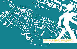
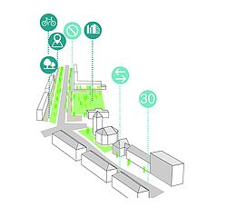
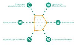
People living in socially disadvantaged neighborhoods generally have poorer chances for good health. Within the framework of this project, it was investigated how city planning can help to strengthen health-promoting conditions in such socially disadvantaged neighborhoods. A particular health problem for socially disadvantaged people in Germany is physical inactivity. In particular, the health-promoting potential of exercise in everyday life is currently not sufficiently recognized and used. Therefore, the project focused on the promotion of "walkability", meaning the pedestrian friendliness of a neighborhood.??
On the basis of an exemplary neighborhood in the Rothenburgsort district in Hamburg, it was investigated which spatial interventions for improving walkability can contribute to the promotion of movement in this district. To this end, criteria were first developed that enable an assessment of the walkability in a district. These criteria, as well as expert interviews, were used to assess the walkability in the study area. The qualities and deficits thus determined served as a basis for the development of a concept for a healthy and walkable Rothenburgsort.
Supervisor
Prof. Dr. Jörg Pohlan
Project participants
Marcel Albers, Simon Altvater, Anna Hensel, Lukas Jahreis, Kay Jensch, Manuela Kiselova, Kim Kubik, Britta
Sabin, Elena Taronna, Diana Togmat, Marie-Luise Ulbrich
Period
October 2015 to March 2016
??The concept of Smart Cities is a popular and contemporary subject that is often discussed. In this context, systems for intelligent management of parking space, as they are currently being developed by the company Siemens, can also be understood as part of the Smart City.
These systems should contribute to optimizing the management of traffic and cities as a whole. Aspects such as the reduction of traffic and emissions, the optimized usage of infrastructure, and the increasing of traffic safety and efficient exploitation of parking spaces are among the principal goals.
In cooperation with employees from the research department of Siemens, a concept is being developed and tested for a digital city model that is dynamically useful for the further planning and simulation of smart city technologies and their applications. For this the city center of Hamburg will serve as an example. Initially, a first feasibility study of such a tool is hence being developed with a trial on the basis of selected parking scenarios. The current concept for the city center of Hamburg (Innenstadtkonzept Hamburg 2014) should also be included in this consideration.
First, the Project contains the conception of a digital city model for the city center of Hamburg; second, the identification of relevant (model) parameters in such a model for integrating the Smart City Application “Smart Parking”; and third, as a point of intersection of all relevant sources, the project will serve as a dynamic tool for planning and communication.
Smart Parking in Hamburg can thereby be seen as a concrete and tangible example for the innovative capturing, processing and communicating of digital information in the public space within a complex system of diverse actors (proprietors of buildings, city administration, municipal operators and providers, retail, citizens, companies, etc.).
Within the framework of the students’ project, a critical reflection on terminology and the conception of Smart Cities should also show the diversity and encourage the different considerations of the discourse.
Along with the collaboration with Siemens, additional cooperation with the study programs Geomatics and the City Science Lab is foreseen for the project implementation.