
Projekte
Laufend
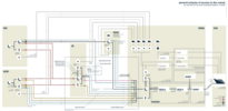
Ab 2022 bringt CityClimate meets CreativeCoding internationale Künstler:innen, Datenanalyst:innen und Datenkurator:innen zusammen, um an neuen Datenkunstprojekten zu arbeiten. Ausgangspunkt für die Projektideen sind die bereits bestehenden digitalen Tools des City Science Lab (CSL): Wie z.B. CoSI (Cockpit-Social-Infrastructure), DIPAS (Digitales Partizipatives System), CUT (Connected Urban Twin) oder PaKOMM (Mixed Reality für partizipative Stadtplanung).
In der ersten Phase im November 2022 sind die Teilnehmer:innen eingeladen, die Lab-Tools und einander bei einem Kick-off-Workshop kennenzulernen. Danach werden sie Teams bilden, die bis März 2023 einen Prototyp entwickeln. Diese konkreten Projektideen werden dann einer externen Jury und den anderen Teilnehmer:innen präsentiert. In der zweiten Phase werden die drei nominierten Projekte mit einem Budget für die Umsetzung ausgestattet. Die Ergebnisse werden im September 2023 öffentlich vorgestellt (konkreter Termin folgt in Kürze).
CityClimate meets CreativeCoding ist eine Kooperation zwischen dem City Science Lab (CSL) der HafenCity Universität Hamburg und der Kulturstiftung des Bundes. Das Climate Service Center Germany (GERICS) unterstützt das Experiment mit seiner Klimaexpertise. CityClimate meets CreativeCoding wird durch das Institut für transformative Nachhaltigkeitsforschung (IASS) evaluiert.
Förderer: Kulturstiftung des Bundes
Projektlaufzeit: November 2022 - Herbst 2023
Partner: Kulturstiftung des Bundes, Climate Service Center Germany (GERICS), Institut for Advanced Sustainability Studies (IASS Potsdam)
Kontakt: Hilke Berger
https://www.creativecoding.city/
The Smart Region Lab was founded in 2021 at the Lucerne University of Applied Sciences and Arts (CH) as a cooperation project with the CityScienceLab Hamburg. The research teams use data-based visualisation and interaction methods to support sustainable development in the small to medium-sized urban and alpine region of Central Switzerland. Central topics of the Lab are mobility, tourism, energy, climate, creative industries, settlement development and infrastructure.
The Smart Region Lab operates on an interdisciplinary basis and literally brings experts from politics, business, administration, culture and civil society together around one data table. The visualisation and simulation techniques support joint decision-making between informed partners and provide the basis for sustainable and cooperative regional development. An open and ethical approach to data is the prerequisite for successful cooperation.
From a technical point of view, the Smart Region Lab aims to combine interactive data tables (RegionScope & MobileScope) with digital platforms and to integrate augmented and virtual reality applications - in close cooperation with the Immersive Realities Research Lab at the Lucerne University of Applied Sciences and Arts. The visualisations, simulations and the specific use of 3D objects are tested in stakeholder workshops and further developed with regard to global challenges and regional issues.
Contact
Annika Kühn
Air pollution is considered to be one of the largest environmental health impacts, with outdoor air pollution causing more than 4.2 million premature deaths worldwide each year. Air quality can vary within city districts and even within street sections. Project Air View in Hamburg is a scientific project of Google and HafenCity University (HCU) to measure, map, and publish hyperlocal air quality data in Hamburg. Project Air View uses an all-electric vehicle equipped with air quality sensors to measure fine particulate matter (PM 2.5), nitric oxide(NO), nitrogen dioxide (NO2), carbon monoxide (CO), carbon dioxide (CO2), and ozone (O3), which are harmful to both our climate and human health. Project Air View’s goal is to bring detailed air quality maps to scientists, city planners, and everyday people to help inspire action that can help further improve the living environment. The data collected by Project Air View is not related to the measurements and modeling carried out by the immission control authority in Hamburg (BUKEA) on the basis of the 39th BImSchV to assess air quality.
Contact
CUT: Urban Data Platforms and Digital Twins for Integrated Urban Development
The ongoing digitization of urban society represents a key opportunity to actively drive urban transformation processes and make cities more sustainable and resilient. This requires innovative forms of cooperation between politics, administration, civil society, science and business and improved (digital) participation tools. The joint project "Connected Urban Twins – Urban Data Platforms and Digital Twins for Integrated Urban Development" (CUT) of the cities of Hamburg, Leipzig and Munich aims to advance the development of data-driven urban twins (Digital Twins) during the five-year project period until 2025. Through the cooperation of the three cities under the leadership of Hamburg, common standards are to be developed for this purpose that can also be replicated and applied across metropolitan regions and other cities on an international scale. The City Science Lab is leading the research activities in the project and works in close collaboration with the Technical University of Munich and the Center for Scalable Data Analytics and Artificial Intelligence in Dresden and Leipzig.
In the project, digital twins will be developed and tested on the basis of concrete use cases for integrated urban development. Cooperation between public and private actors will be promoted and citizens are going be involved as co-researchers. With the help of practice-oriented technology research, exploratory modelling and simulation, as well as social science methods and real-life experiments, insights will be gained for a public welfare-oriented and transformative application of CUT. The project results are to be incorporated into a cross-city exchange of experiences and promote sustainable knowledge building and transfer. For this purpose, they are to be shared at an early stage, solutions are to be developed flexible, cross-city and user-oriented, communicated and made available as modular open source.
Sponsor
Federal Ministry of the Interior, for Building and Home Affairs
Partner
Free and Hanseatic City of Hamburg, City of Munich, City of Leipzig, Technical University of Munich, Center for Scalable Data Analytics and Artificial Intelligence
Project Duration
2021-2025
Contact
The United Nations Innovation Technology Accelerator for Cities (UNITAC-Hamburg) is a collaboration between UN-Habitat, the UN Office for ICT (OICT) and HafenCity University. The Accelerator works with a variety of innovation, prototyping and applied research methodologies to develop innovative solutions that accelerate the achievement of Sustainable Development Goals related to cities and urbanization.
Through a diverse team of urban experts, software developers and technology specialists, UNITAC Hamburg develops and implements applied research projects in the intersection between urbanization, innovation and technology. The Accelerator develops a bespoke urban technology innovation acceleration methodology that can be used to analyze real urban challenges and urbanization trends and develop scenarios, prototypes, testable solutions or similar outputs which demonstrate the power of digital technologies to solve urban challenges.
The solutions developed by UNITAC-Hamburg are tested and piloted with local governments and other partners in Hamburg and across the world, through a new network of partners from academia, private sector, governments and investors. Learnings are documented and published through high-quality guides and toolkits that can be used by policy makers to ensure that smart cities are inclusive, sustainable and people-centered.
For more information on UNITAC-Hamburg, watch the video on Youtube.
Partners
UN-HABITAT (The United Nations Human Settlements Programme) and UN OICT (The UN Office of Information and Communications Technology)
Project Duration
October 2020 – September 2024
Contact
Cooperation with the LIG Landesbetrieb Immobilienmanagement und Grundvermögen
The "LIG Project" is a cooperation between the State Authority for Real Estate Management and Land Properties (Landesbetrieb Immobilienmanagement und Grundvermögen - LIG) and the CityScienceLab in the field of data-based strategic land and urban development. The HCU CityScienceLab supports the LIG as a scientifically creative partner in the agile and spontaneous development of innovative services and processes that go beyond the procedures established in the LIG and address previously unknown needs. In experimental-explorative research and development projects, new tools and methods for the visualization and analysis of urban data in the context of strategic land and urban development are developed for the LIG.
Partner
Landesbetrieb Immobilienmanagement und Grundvermögen (LIG)
Project Duration
October 2019 – April 2021
Contact
PaCOMM: Partizcipation collaborative and multimedia
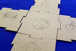
Digital public participation has become a fixed format in democratic societies. Although early, comprehensive, and transparent involvement is key for successful planning processes, there are only a few encouraging experiments of multimedia participation approaches. Existing ones are often not tailored to the needs of the citizens. The application of different forms of representations, such as thematic maps, diagrams, aerial photographs, videos, and animations so far is only used isolated.
This project addresses this issue by developing application-specific integrative solutions. Besides CityScopes, we primarily rely on mixed reality approaches via smartphone, tablet and Head-Mounted-Displays, as they can improve spatial imagination and create experiences that are sharable in real-time. Following the goal to create an intuitive and accessible application that appeals equally to young technophile users as well as older generations, gamification elements will be introduced into the process, too.
Since increasing citizen contributions exceed the evaluation capacity of planning offices, procedures of Machine Learning or Natural Language Processing assist in extracting relevant core statements quickly. In the long term, PaKOMM contributes to more transparent, effective and efficient decision-making in collaborative participation processes.
For more information on our project, watch our project video on Youtube.
Sponsor
Hamburg Ministry of Science, Research and Equality (BWFG)
Partner
g2lab (Lab for Geoinformatics and Geovisualization, HCU Hamburg) und FTZ Digital Reality, HAW Hamburg
Project Duration
2020 - 2023
Contact
CoSI: The Cockpit Social Infrastructure
When planning urban and social infrastructure, decision-making processes by public actors/administrators are often lengthy and rely on heterogeneous datasets in incomplete databases. The planning process, especially the definition of planning goals/needs, is often delayed due to time-consuming data procurement and assessment processes.
The Cockpit Social Infrastructure (CoSI) is a digital analysis and planning tool, which bundles, visualizes and integrates statistical and georeferenced data to planners of social infrastructure in identifying needs and accelerating planning processes, by means of an easily accessible user interface.
For this purpose, the database structures built up by the Urban Data Platform of the City of Hamburg were used to establish a GIS-based web application, which provides planners with analytical functions to identify socio-demographic relationships to recognize trends, and to determine relationships between the existing infrastructure and the relevant target groups. In the following, we describe how the tool can be used to identify locations and potentials for infrastructure development. The results of these analyses can be visualized and exported directly from CoSI and used as a basis for decision-making and discussion. The workflow follows a three-step logic from the visualization of data, through the analysis, i.e. the contextual linking of information, to the simulation of the effects of potential measures.
CoSI has been designed in an agile process in close cooperation with the urban planners of the Quartiersinitiative Urbanes Leben (QuL) working group since 2018 and was transferred to a pilot in January 2020, which is now in active operation citywide. Thanks to the intensive cooperation, the project is met with a predominantly positive response within the administration and is expected to be further developed in coordination with the UDH and CUT projects from 2021 onwards. It will be enhanced with prognostic and simulation features to make the rich urban data we have available for social and sustainable urban development.
For more information on our project, watch our project video on Youtube.
Sponsor
Bezirksamt Hamburg-Nord
Partner
Landesbetrieb Geoinformation und Vermessung Hamburg, Bezirksamt Hamburg-Nord, Senatskanzlei Hamburg / Amt für IT und Digitalisierung
Project Duration
2018 - 2020
Contact
City Science Summit (1.081 Zeichen)
On October 1st, 2019, the 3rd international City Science Summit took place for the first time in Hamburg at the CityScienceLab, HafenCity University Hamburg, in cooperation with the MIT Media Lab. Previous venues were Andorra and Shanghai.
The two-day international conference on digital urban research focused on sustainable solutions for the city of the (digital) future. The conference was opened with a keynote speech by the internationally renowned architect Lord Norman Foster on the informal development of urban agglomerations. Following the kick-off event in the Elbphilharmonie, around 500 participants exchanged views on sustainable strategies for future urban development against the background of digitisation, including the following topics: Mobility of the future, modern citizen participation and digital city models. The guiding motto "Cities without" plays with the negation as a positive figure of thought. How, for example, could traffic function without cars, administration without bureaucracy, economy without money, education without schools, or participation without barriers? On the second day of the conference, these and other topics were explored in greater depth in individual sessions and workshops.
Partners
City Science group, Media Lab, MIT | ahoi.digital – The alliance of Hamburg universities for computer science
Project Duration
2019
Sponsors
ahoi.digital, German Research Foundation, Hamburger Hochbahn AG, Hamburg Port Authority, ' Lebendige Stadt' Foundation, Europe-Center – Uwe Heinrich Suhr Foundation
Urban Data Hub (since 2017)

Currently, city administration uses different systems, which work independently of each other to fulfil specialized tasks. Therefore, the full and overall evaluation of complex issues as well as the fast implementation of measures are naturally tortuous, redundant and personnel-intensive processes of coordination and data collection. The extensive interlinking of systems requires an appropriate data infrastructure to effectively introduce digital technology in a modern city. In a smart city, without the linking of data through an urban platform the services and applications cannot be implemented effectively.
The Urban Data Hub is an ongoing co-operation project between the CityScienceLab and the LGV which, as a competence centre, focusses on the development of an Urban Platform as a central data hub for Hamburg. Through the integration and interlinking of standardized data and web services it provides gathered urban data, thereby ensuring that diverse user groups benefit from it.
Within the framework of this project the task of the CityScienceLab concentrates on the scientific monitoring, including the investigation of development needs and the prototypical realization of City-Cockpits.
For more information on our project, watch our project video on Youtube.
Sponsor
Free and Hanseatic City of Hamburg
Project Duration
01.08.2017 – 01.08.2020
Partner
LGV
Contact
Baltic City Science Network (seit 2017)
Ziel des Baltic City Science Network Projekts ist die Initiierung von Forschungskooperationen im Feld der digitalen Stadtanalyse mit Hilfe von partizipativen Workshops und interaktiven Tools.
Langfristig soll ein Bewusstsein für die Aktivität, Innovation und Praktiken bei der Anwendung digitaler Werkzeuge für partizipative und kollaborative Stadtentwicklungsherausforderungen geschaffen werden. Außerdem sollen die Zusammenarbeit, der Wissensaustausch und gemeinsame Projekte in der Baltischen Region gefördert werden.
Das Baltic City Science Network umfasst Forschungsreisen von Vertretern des CityScienceLabs der HCU an sechs Universitäten im Baltischen Raum zur Durchführung von Workshops mit eingeladenen Experten aus den Bereichen Kulturwissenschaften, Stadtentwicklung, IKT und Architektur.
Förderer
Freie und Hansestadt Hamburg
Projektlaufzeit
1. Dezember 2017 - 30. November 2019
Partner
Aalto University, Tallinn University of Technology
Kontakt
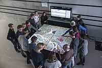
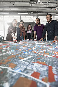
DIPAS: Digital Participation System (since 2017)
The CityScope tool is to be developed into a digital participation system for urban development projects. For this purpose, the Hamburg Authority for Urban Development and Housing (BSW), the office for geoinformation and land surveying (LGV) and the HafenCity University joined forces in the realm of a joint research and development project. The core objective of the project is to merge the online participation tool of the city of Hamburg with the city model CityScope, developed by the CitySciene Lab, and to expand it to an integrated, digital participation system (DIPAS) that can be used online and on-site. With DIPAS, for the first time, an application for informal citizen participation in planning is developed without discontinuity of media.
In the co-operation project, the CSL is undertaking the scientific accompaniment, knowledge processing and development of analysis scenarios.
Sponsor and Partner
BSW & LGV
Contact
More Information
Digital Platform ahoi.digital (since 2017)
Within the overall strategy of the digital city the senate of Hamburg and the Universities (UHH, TUHH, HAW) in cooperation with the CSL plan to realize the IT platform „ahoi.digital“. To strengthen IT excellence, it creates a computer science hub which has the potential to systematically increase the capacity of information technology. In this sense, the thematic focus of the newly developed structures and projects lies on: Cognitive Learning Systems, Smart Systems/ Cyberphysical Systems, Information Governance and Data Science.
Digital Platform Hamburg ahoi.digital: Hamburg's universities want to strategically expand their digitalization and information technology capacities. Structures and projects under the following themes are to be developed:
- Cognitive Learning Systems
- Smart Systems / Cyberphysical Systems
- Information Governance
- Data Science
Sponsor
Free and Hanseatic City of Hamburg & Federal Government
Partners
TUHH, HAW, University of Hamburg
Contact
Prof. Dr.-Ing. Jörg Rainer Noennig
More Information (in German)
Guest Research Program (since 2016)
The guest research program "City of the Future" for city research by the ZEIT Foundation at the HCU provides a one-week stay for scholars and experts as well as fellowships over a period of three months for international researchers and postdocs working at the CityScienceLab.
The guest researchers who have worked at the CSL are listed on our team page.
Sponsor
ZEIT Stiftung Ebelin und Gerd Bucerius
Project Duration
Three years
Contact
Curating (in) the City. New Challenges for Urban Art
Contemporary curatorial practice no longer takes place only in classical art spaces such as galleries, museums or theatres, but instead intervenes into public urban spaces. What becomes particularly evident in the light of these expansions of the curatorial is a shift in the conditions and mechanisms that determine how contemporary public art is produced and how it impacts society today. Accordingly, the research project will analyse the fundamental transformations that lead to an expansion of the curatorial with regard to the production of contemporary public art. On the basis of three international case studies, the research project investigates the specific actors‘ constellations and modes of organization that lead to specific (institutional) forms of cooperation and organization (1). Secondly, it examines the working methods of contemporary curators. It is to be examined to what extent the requirements and working activities of the curators converge with the changes in the field of art (2). Thirdly, the relation between curatorial practices and attempts to establish new public spheres are critically analysed.
The aim is to deliver a detailed analysis on the one hand of the observable intersections of art production and urban culture, on the other hand of the shift from education to the assembly of new publics. The new challenges of urban art production lead to a practice of ‘curating (in) the city’, which has to be analysed in its function for the production of art specifically in the city as well as for the creation of urban culture.
Sponsor
funded by the German Research Association DFG – ZI 1627/3-1
Project Duration
01.04.2019 - 31.03.2022
Contact
Abgeschlossen
OCTOPI: Open City Toolkit for Interactive Planning in Integrated Urban Development
The Open City Tookit for interactive planning in integrated urban development is a cooperation with Gesellschaft für Internationale Zusammenarbeit (GIZ) GmbH in India and Ecuador. Further partners are the municipal administrations in Ecuador and India, local tech companies and universities. It started in autumn 2019 and runs for 1.5 years.
The Open City Toolkit is a web-based geographic information system for multi-touchtables that is optimised for the use by non-GIS-experts. It supports integrated and participatory urban planning processes around the world, fostering dialogue between governments and citizens and exchange of knowledge and data between government departments.
The software for this project is based entirely on open-source-components (GRAS GIS and GeoServer for the spatial calculations and analyses in the background, Node.js and Angular für the user interface and internal communication between the systems) and will be made available as open-source-software. The components of the Open City Toolkit are the hardware, a standard software package, a manual and an interaction guide for workshops.
The Open City Toolkit is being piloted in two cities: 1. Bhubaneswar, India and 2. Latacunga, Ecuador. It is tailored to the local planning requirements of these two pilot cities, but at the same time offers open interfaces for the development of further functionalities in new contexts.
In Bhubaneswar, many people are living in slums and the local government would like to use the open city toolkit to identify land for the construction of affordable housing. In Latacunga, parts of the city are exposed to high risk from the Cotopaxi volcano and the local government wants to use the open city toolkit to develop collective solutions for volcanic risk governance. In both cases, the Open City Toolkit will support participatory decision-making and consolidation of data from various city departments.
Sponsor
Deutsche Gesellschaft für Internationale Zusammenarbeit (GIZ) GmbH
Partner
Deutsche Gesellschaft für Internationale Zusammenarbeit (GIZ) GmbH, municipal administrations in Ecuador and India, local tech companies and universities
Project Duration
October 2019 – March 2021
Contact
GRACIO
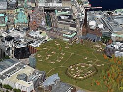
In 2019, a competition will take place for the design of a new district: Grasbrook. Located to the south of Hamburg's HafenCity in the northeast part of Kleiner Grasbrook, an area currently dominated by a large warehouse and light harbor industry, the new district should be a home for innovation – a model for a lively mix of offices and housing. To achieve this, competing design firms will need to able to test, iterate, and adapt their designs over the course of the competition. The main aim of the Gracio project is to support this process. Using methods and tools for digital urban research, the HCU CityScienceLab will create an interactive city model for Grasbrook. The model, called a CityScope, will be used to support planning and decision-making in panel discussions, to visualize complex spatial and social contexts of the project, and to model development scenarios based on important urban planning qualities (e.g. mobility and accessibility, energy consumption, and air pollution).
Sponsor
Behörde für Wissenschaft, Forschung und Gleichstellung (BWFG)
Project Duration
November 2018 - 15. November 2020 (24 Monate)
Contact
Julia Sievert, Dr. Jesús López Baeza and Aleksandra Sliusarenko
MICADO
Today, migration is part of the urban reality and confronts cities and municipalities with the challenge of organising the arrival process in a way that highlights and supports the positive effects of migration. By using new technologies of data analysis and data integration on the one hand and easily accessible audio-visual interfaces on the other, MICADO will provide a technical solution to make arrival and participation processes more efficient. These systems should facilitate communication with and between local authorities and facilitate access to relevant information.
The user-oriented data services, which integrate both local and regional as well as national migration-related information, focus on the four areas of work, education, housing and health and the three target groups of migrants, local authorities and initiatives in the field of migration. The services will be developed and tested in co-creative processes in cooperation with the target groups.
MICADO is part of the EU research programme Horizon 2020 and is coordinated by the CityScienceLab of the HCU Hamburg. The consortium consists of 15 partners from five EU countries, including research institutes, public institutions and companies.
Sponsor
Europäische Kommission Horizon 2020
Project Duration
01.01.2019 – 30.06.2022
Partner
Hamburg - Freie und Hansestadt Hamburg (FHH), Landesbetrieb Geoinformation (LGV), Hamburgisches Weltwirtschaftsinstitut (HWWI)
Antwerpen - University of Antwerp (CeMIS), City of Antwerp (OCMW), Atlas Integratie & Inburgering Antwerp (ATL), Digipolis (DIG)
Bologna - University of Bologna (UNIBO), Citta di Bologna (ASP), CSI Piemonte
Madrid - Illustre Colegio Nacional de Doctores y Licensiados en Ciencias Politicas y Sociologia (CPS), Universidad Rey Juan Carlos, Madrid (URJC), Direccion General de Servicios Sociales e Integracion Social-Consejeria de Politica Social y Familia de la Communidad de Madrid (DGSSIS)
Vienna - Technical University of Vienna/ SimLab (TUW), SYNYO GmbH Vienna (SYN)
Contact
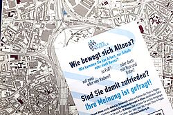
Cities4People (2017 - 2020)
Cities4People covers five European cities and municipalities: Budapest in Hungary and Trikala in Greece, the district of Oxfordshire in Great Britain and the Istanbul district of Üsküdar in Turkey. In Hamburg’s district Altona (Neue Mitte Altona and neighboring areas) the project aims to set up mobility communities, which will not only include citizens but also public authorities, transport and mobility providers and innovation experts. The participation focuses on a people-oriented approach to traffic and mobility (People-Oriented Transport and Mobility = POTM) and therefore relies on the development and supply of appropriate structures and instruments that allow the communities to actively design local mobility systems. In Hamburg, Cities4People is jointly managed by the CityScienceLab and the Department of Urban Planning and Regional Development at HafenCity University.
Sponsor
European Commission – Horizon 2020
Partners
- Copenhagen Business School
- Oxfordshire County Council
- University College London Institute of Health Equity
- Free and Hanseatic City of Hamburg (Altona District Authority, office of the senate Hamburg)
- HafenCity University
- Stichting Waag Society
- White Research
- KTI Institute for Transport Sciences
- City of Budapest
- municipality Üsküdar
- University of Istanbul
- E-Trikala
- Q-Plan International
Project Duration
01.06.2017 - 30.05.2020
Contact
More Information
SmartSquare (2017-2020)
The data-oriented inventorying, analysis and exemplary modelling of Hamburg's cathedral square is intended to provide an integrated, smart service-model for the revitalization of the currently unused location. A methodology is developed to "survey" squares, which leads to the implementation of smart services into small-scale structures.
Sponsor
BMBF
Partner
Stiftung Helms-Museum / Archaeological Museum Hamburg, Hamburg@work, eCulture.info
Project Duration
01.03.2017 - 29.02.2020
Contact
More Information (in German)
FindingPlaces (2016)


Finding Places was a cooperation project of the HafenCity University and the City of Hamburg. In the period from May 26thto July 15th2016 the people of Hamburg were – in numerous participatory workshops at CityScopes – searching for public areas suitable for the construction of accommodation for refugees. The task: to find areas which allow the accommodation of 20,000 refugees in total.
The workshops were moderated by STEG Hamburg (Stadterneuerungs- und Stadtentwicklungsgesellschaft Hamburg) and scientifically monitored by the CityScienceLab. Furthermore, representatives of the district authorities as well as of the Central Coordination Committee Refugees Hamburg (ZKF) supported the discussions with their expertise.
During the workshops, almost 400 participants proposed specific areas and extensively discussed advantages and disadvantages. 161 commented proposals were sent to the city and checked within 14 days. The results were then published on the FindingPlaces-website as well as in a leaflet.
The project aimed to encourage a city-wide dialogue on how and where to find accommodation for a large group of refugees arriving in Hamburg. At the same time, it showcased the complexity of planning processes and thus helped develop an increased acceptance within the civil society. This led to a rewarding combination of the participants’ local knowledge and the expertise of the authorities and science. The participatory workshops not only led to the discussion of specific locations, but rather encouraged a discourse in the context of different interests (living / industry / maintenance) and legal planning requirements.
Sponsor
Free and Hanseatic City of Hamburg
Partner
Office of the senate, ZKF, STEG Hamburg
Contact
More Information
Project Website (in German)
Results brochure (in English)
The Port City Model (PCM) is a project that investigates multimodal land transportation related to cruise tourism, focusing on comfort and efficiency from the user perspective. To do so, it combines data analysis and visualization with simulation of future scenarios. The outcome of the project is a software tool running on an interactive hardware platform that simplifies decision-making and facilitates dialogue among the stakeholders involved in the optimization of cruise passenger routes planning as well as affecting other port and port-related processes. This paper offers a description of the project with special focus on Agent-Based simulations. More specifically, the project studies the most frequent flows and routes in the city of Hamburg, where cruise tourism is strongly related to its Central Train Station, since a great amount of passengers arrive to the city by train. Due to its size and the vast affluence of people, Hamburg Central Station is a major challenge spot in multimodal land transportation related to cruise tourism, especially regarding orientation and perception of spatial quality of incoming cruise passengers on their way to their respective cruise terminals. Aiming to enhance comfort and efficiency through testing alternative mobility scenarios, this work acknowledges that the potential optimization of any port and port-related mobility process constitutes a major priority, and improvement to itself and to the entire harbour system.
Förderer
Hamburg Port Authority (HPA)
Projektlaufzeit
October 2018 - July 2019 (10 Monate)
Kontakt