
Hydrography
The master programme in Geodesy and Geoinformatics with specialisation in Hydrography has a standard duration of 2 years and presents a distinctive feature, unique in Germany: the programme has been internationally certified as category A programme (the highest level) by the FIG/IHO/ICA International Board on Standard of Competence for Hydrographic Surveyors and Nautical Cartographers. The Hydrography specialisation is completely taught in English and currently 71 students from 20 countries are enrolled (June 2021).
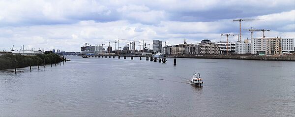
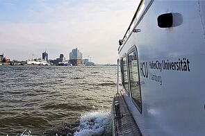
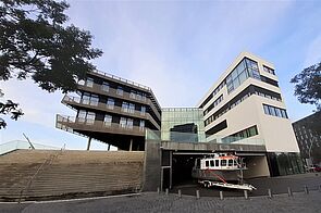
The HafenCity University is located at the River Elbe close to the port of Hamburg and within the quarter named HafenCity, Europe's largest urban development project. The Free and Hanseatic City of Hamburg is Germany’s second largest city and is located approximately 100 km of the North Sea. The River Elbe has been the city’s gateway to the world, being Europe’s third largest port, after Rotterdam and Antwerp. The city is also one of the Headquarters of the Federal Maritime and Hydrographic Agency of Germany (Bundesamt für Seeschifffahrt und Hydrographie) and a major international and domestic tourist destination that offers different historic and cultural options.
You are interested in enrolling in the master program "Geodesy and Geoinformatics" with specialization in "Hydrography" and looking for further information?
Then join the "Digital Information Meeting for Prospective Hydrography Students" on the 14/06/2023 at 2 pm (CEST) where we provide further details about the study program and answer any questions you might have! To participate in the meeting, please write an informal email to ellen.werner(at)hcu-hamburg.de and we will send you a zoom meeting link.
Hydrography belongs to the applied sciences, dealing with the measurement and description of water bodies, which are the oceans, seas, rivers, lakes, as well as their adjacent coastal areas. Hydrography is crucial for efficiency and safety in the navigation of ships. This is achieved by studying the water bodies and predicting their changes over time. Surveys in the discipline of hydrography also support marine activities, including economic development, scientific research and environmental protection (www.iho.int).
With the help of hydrography, monitoring of inland and coastal waters as well as marine infrastructures are accomplished. The analysis of climate trends, water level predictions and seabed characterisation are included in this vast field of hydrography. Further information can be found on website of the International Hydrographic Organization (IHO): https://iho.int/en/what-is-hydrography
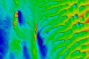
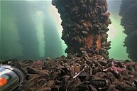
As a science and profession, hydrographic surveying has evolved into an occupation that is multi-disciplinary. Hydrographers today are involved with various aspects of water related data including bathymetric mapping of the ocean floor, investigating sub-sediment layers, monitoring underwater objects and constructions, exploring minerals that lie far beneath, managing large marine data sets and observing and studying ocean environments.
Hydrography offers exciting and versatile tasks in a wide range of professional fields both out on the oceans on vessels or inside offices. Currently, there is a great demand of highly qualified hydrographers in many industries, governmental authorities and research facilities.
Application is possible between June 1st and July 15th (online only). The programme starts every year in October. More information about the application process and requirements can be found here.
Please also note that there is NO university fee in Hamburg anymore. Each semester students are required to pay a semester contribution that includes the costs for the »semester ticket«, a ticket that permits free travel on Hamburg’s public transport system.
The master programme in Geodesy and Geoinformatics with specialisation in Hydrography is composed by modules of Geodetic Measurement Techniques, Geoinformation Technology and Hydrography.
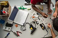
The hydrographic modules include exercises and practical courses, which give students the opportunity to apply the previously gained theoretical knowledge within a practical environment. In the third semester, the final field project (Supplementary Field Training) takes place, where students carry out complex multidisciplinary hydrographic projects in small groups. The individual project tasks vary slightly from year to year, but always include the following components: project planning, preparation, data acquisition, processing and evaluation of the system performance.
More information about the content of the course can be found here.
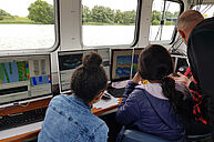
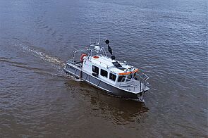
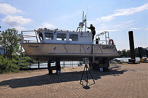
With the DVocean, HCU owns a new survey vessel that can be used not only for teaching but also for research projects. The aluminium vessel has a length of about 8 m and a width of 2.6 m. It can be transported by trailer to distant survey areas. In addition to the skipper, the cabin has room for six people with sufficient free working space.
Key Facts
| Total length | 8.8 m |
| Total width | 2.6 m |
| Maximum draft | 0.9 m |
| Height of the boat above the waterline | 2.8 m |
| Propulsion | 2 outboards + bow thruster |
| Maximum number of persons on board | 10 |
| Shipyard | Lübeck Yacht Trave Schiff GmbH |
| Launched | 2019 |
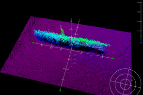
The DVocean will be equipped with a state-of-the-art hydrographic measurement system (multibeam echo sounder, sub-bottom profiler, magnetometer, inertial navigation system, GNSS and sound velocity profiler/ CTD).
The hydrographic instruments can be mounted on the bow, on the sides as well as on the stern, recording data simultaneously. On the roof, it is possible to install a laser scanner or compact mobile mapping systems besides the GNSS antennas to record the terrain above the waterline.
Special or lend equipment for detailed surveys or specific tasks can also be easily integrated into the boat's measurement system. In addition to the high-end equipment on the boat, some low-cost systems such as single-beam echo sounders, fish finders or ROVs (remotely operated vehicle) are owned by HCU.
The boat has been optimised for use in shallow water. Fields of application include for example the exploration and monitoring of waterways and their built-up banks and the generation of 3D surface models of the water bottom based on bathymetric echo sounding data. In the future they can be combined with ship-based laser scanner measurements to conduct innovative research by combining data of below and above the water line for monitoring the embankment including its constructions.
Naming of the Vessel
The vessel’s naming DVocean is in memory of Professor Delf Egge and Professor Volker Böder, who were very committed to the HCU’s Hydrography course and contributed significantly to its development. The letter “D” is the initial letter of Prof. Delf Egge and the letter “V” is the initial letter of Prof. Volker Böder. The pronunciation shall further remind of the English word "devotion".
Have a look at our 360° virtual tour here.
The field of Hydrography yields a variety of job opportunities, ranging from the private industrial sector to the non-commercial and academic sectors. Occupation in the private sector involves work at worldwide project surveys, several types of surveys supporting dredging and underwater construction operations (e.g., wind parks for power generation), pipeline investigation and monitoring and marine exploration. Hydrographers can also work in software and equipment companies. Job profiles here include software developers, system installers, or as sales manager, distributing technological novelties.
Primarily in the public sector, employers of hydrographers are the national hydrographic offices, federal waterways and shipping administration and port authorities. Typical tasks of hydrographers are the monitoring of the water depth in regular intervals as well as during construction projects or after special weather occurrences. Furthermore, another part of the work includes the issuing of nautical charts and/or prepare other data products with water depth information.
Other hydrography related tasks deal with data management and the visualization using geographic information system. By combining and simultaneous displaying different data sets a joint interpretation can be done and products like maps or digital derivatives for distribution and further usage can be generated.
Research in hydrography is extensive and fascinating. It relies on a variety of scientific and engineering disciplines. Two of the main application fields are paramount at the beginning of the third millennium. The first is the control of environmental quality and the sustainable management of living natural resources, the second is the effective exploration and exploitation of energy resources and minerals. Other topics cover marine autonomics and underwater vehicles. Subject matters range from dynamic positioning and sensor fusion to machine learning and artificial intelligence.
In conclusion, the graduates from the master programme in Geodesy and Geoinformatics with a specialisation in Hydrography have very good job perspectives and usually secure a job shortly after their graduation. Overall, opportunities of employment are endless. Hydrographers can find occupation from large globally operating companies to smaller local companies, at authorities, as scientist or educator. For further information please have a look at the videos posted by the International Hydrographic Organization (IHO): https://iho.int/en/brochure-presentation-videos
HCU closely cooperates with different institutes and authorities dealing with Hydrography or Bathymetry. The students have the opportunity to apply for internships or write their thesis in cooperation with HCU partners. To receive a list, please contact our department.
Software
In order to ensure the best preparation of the students, the HafenCity University cooperates with Quality Positioning Services (QPS) and Teledyne CARIS.
On board of the university’s vessel DVocean, students learn to acquire hydrographic data using the data acquisition software package QPS Qinsy amongst others. For data processing, analysing and visualisation the software packages Qimera, Fledermaus, FMGT, FM Midwater from QPS as well as HIPS and SIPS from Teledyne CARIS are used.
As a leading academic institution in Hydrography several research projects are conducted at the HafenCity University. More information can be found here.
Univ.-Prof. Dr.-Ing. Harald Sternberg
(Hydrography and Geodesy)
Raum 4.027
Tel.: +49 40 42827 – 5300
M.Sc. Mona Lütjens
Raum 02.01.03 (Campus Tower)
Tel.: +49 40 428 27 – 5511
E-Mail: mona.luetjens(at)hcu-hamburg.de
M.Sc. Friederike Köpke
Raum 02.01.04 (Campus Tower)
Tel.: +49 40 428 27 – 5337
Project INDEX
M.Sc. Tanja Dufek
Raum 02.01.05 (Campus Tower)
Tel.: +49 40 428 27 – 5314
E-Mail: tanja.dufek(at)hcu-hamburg.de
M.Sc. Dilip Adhikari
Raum 02.01.05 (Campus Tower)
Tel.: +49 40 428 27 - 5233
E-Mail: dilip.adhikari(at)hcu-hamburg.de
M.Sc. Niklas-Maximilian Schild
Tel.: +49 40 42827-5238
M.Sc. Markus Kraft
Raum: 02.01.05 (Versmannstraße 2)
Tel.: +49 40 42827-5434
E-Mail: markus.kraft(at)hcu-hamburg.de
M.Sc. Lukas Klatt
Raum: 02.01.04 (Versmannstraße 2)
Tel.: +49 40 42827-5346
E-Mail: lukas.klatt(at)hcu-hamburg.de