Geodesy and Geoinformatics a la Hamburg
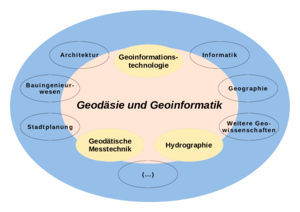
Geodesy and Geoinformatics is concerned with spatially orientated data, simply expressed with the "where" questions in everyday live.
Geodesy and Geoinformatics is an exciting interdisciplinary field, which covers a broad range from applications in geodetic engineering to land use planning, land management and environmental sciences and uses state-of-the-art technologies to accomplish this.
HCU offers the study of Geodesy and Geoinformatics in courses which complement each other. The training is practical and project-oriented.
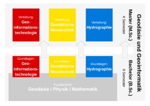
The bachelor's course in Geodesy and Geoinformatics covers six semesters and results in a Bachelor of Science (B. Sc.) degree. The bachelor's degree opens the door to a vocational entry into the professional world.
However, you can also choose to continue and supplement your studies by applying for the four-semester master's course, which results in the Master of Science (M. Sc.) degree.